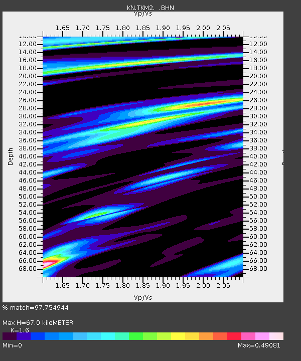
TKM2 KN.TKM2 - Earthquake Result Viewer
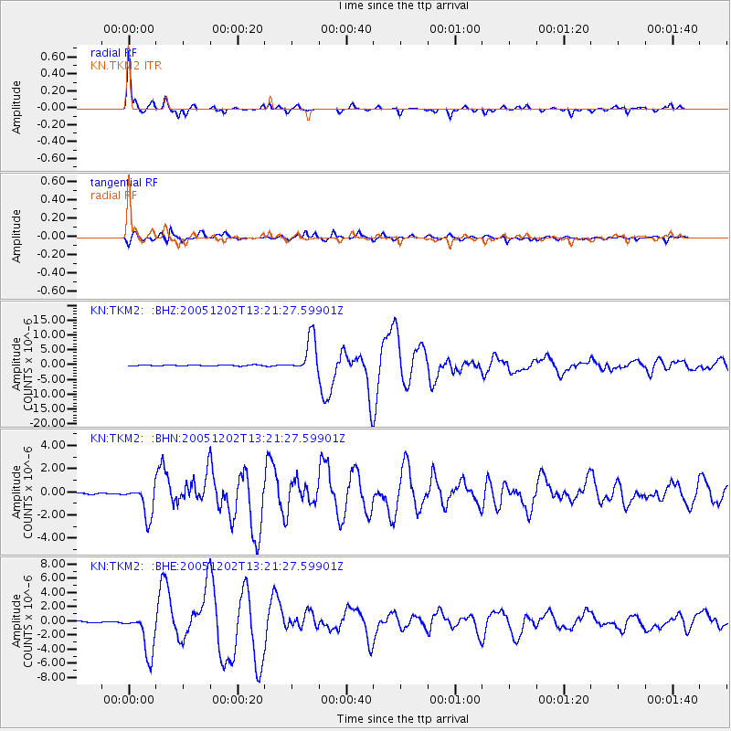
Earthquake location: Near East Coast Of Honshu, Japan
Earthquake latitude/longitude: 38.1/142.1
Earthquake time(UTC): 2005/12/02 (336) 13:13:09 GMT
Earthquake Depth: 29 km
Earthquake Magnitude: 6.1 MB, 6.3 MS, 6.5 MW, 6.4 MW
Earthquake Catalog/Contributor: WHDF/NEIC
Network: KN Kyrgyz Seismic Telemetry Network
Station: TKM2 KN.TKM2
Lat/Lon: 42.92 N/75.60 E
Elevation: 2020 m
Distance: 49.6 deg
Az: 297.827 deg
Baz: 71.798 deg
Ray Param: 0.06852759
Estimated Moho Depth: 67.0 km
Estimated Crust Vp/Vs: 1.60
Assumed Crust Vp: 6.306 km/s
Estimated Crust Vs: 3.941 km/s
Estimated Crust Poisson's Ratio: 0.18
Radial Match: 97.754944 %
Radial Bump: 206
Transverse Match: 93.06948 %
Transverse Bump: 358
SOD ConfigId: 2422
Insert Time: 2010-03-08 21:08:05.683 +0000
GWidth: 2.5
Max Bumps: 400
Tol: 0.001

Signal To Noise

ChannelStoNSTALTA
KN:TKM2: :BHN:20051202T13:21:27.59901Z11.8139721.395676E-61.1813774E-7
KN:TKM2: :BHE:20051202T13:21:27.59901Z36.354983.0275824E-68.327834E-8
KN:TKM2: :BHZ:20051202T13:21:27.59901Z39.7856676.1633145E-61.5491294E-7
Arrivals
Ps6.8 SECOND
PpPs26 SECOND
PsPs/PpSs33 SECOND