TKM2 KN.TKM2 - Earthquake Result Viewer
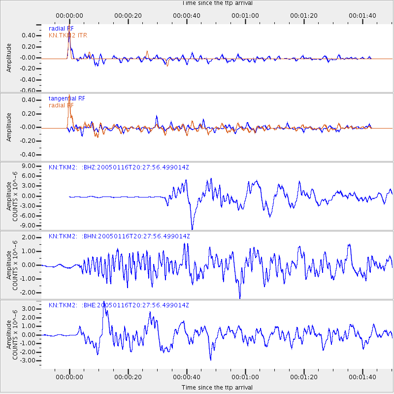
Earthquake location: W. Caroline Islands, Micronesia
Earthquake latitude/longitude: 10.9/140.8
Earthquake time(UTC): 2005/01/16 (016) 20:17:52 GMT
Earthquake Depth: 25 km
Earthquake Magnitude: 6.3 MB, 6.7 MS, 6.6 MW, 6.6 MW
Earthquake Catalog/Contributor: WHDF/NEIC
Network: KN Kyrgyz Seismic Telemetry Network
Station: TKM2 KN.TKM2
Lat/Lon: 42.92 N/75.60 E
Elevation: 2020 m
Distance: 64.5 deg
Az: 312.367 deg
Baz: 98.959 deg
Ray Param: 0.05882667
Estimated Moho Depth: 64.5 km
Estimated Crust Vp/Vs: 2.00
Assumed Crust Vp: 6.306 km/s
Estimated Crust Vs: 3.153 km/s
Estimated Crust Poisson's Ratio: 0.33
Radial Match: 96.40098 %
Radial Bump: 400
Transverse Match: 87.91794 %
Transverse Bump: 400
SOD ConfigId: 5233
Insert Time: 2010-03-08 21:08:51.135 +0000
GWidth: 2.5
Max Bumps: 400
Tol: 0.001

Signal To Noise

ChannelStoNSTALTA
KN:TKM2: :BHN:20050116T20:27:56.499014Z1.86254721.4977961E-78.041654E-8
KN:TKM2: :BHE:20050116T20:27:56.499014Z7.4020523.3268154E-74.49445E-8
KN:TKM2: :BHZ:20050116T20:27:56.499014Z9.2385138.298615E-78.98263E-8
Arrivals
Ps11 SECOND
PpPs30 SECOND
PsPs/PpSs40 SECOND