TKM2 KN.TKM2 - Earthquake Result Viewer
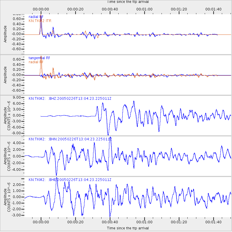
Earthquake location: Off W Coast Of Northern Sumatra
Earthquake latitude/longitude: 2.9/95.6
Earthquake time(UTC): 2005/02/26 (057) 12:56:52 GMT
Earthquake Depth: 36 km
Earthquake Magnitude: 6.0 MB, 6.7 MS, 6.8 MW, 6.7 MW
Earthquake Catalog/Contributor: WHDF/NEIC
Network: KN Kyrgyz Seismic Telemetry Network
Station: TKM2 KN.TKM2
Lat/Lon: 42.92 N/75.60 E
Elevation: 2020 m
Distance: 43.6 deg
Az: 338.659 deg
Baz: 150.344 deg
Ray Param: 0.07233806
Estimated Moho Depth: 60.5 km
Estimated Crust Vp/Vs: 1.69
Assumed Crust Vp: 6.306 km/s
Estimated Crust Vs: 3.726 km/s
Estimated Crust Poisson's Ratio: 0.23
Radial Match: 96.316505 %
Radial Bump: 293
Transverse Match: 84.300285 %
Transverse Bump: 400
SOD ConfigId: 2455
Insert Time: 2010-03-08 21:09:31.418 +0000
GWidth: 2.5
Max Bumps: 400
Tol: 0.001

Signal To Noise

ChannelStoNSTALTA
KN:TKM2: :BHN:20050226T13:04:23.225011Z5.50269039.780772E-71.7774526E-7
KN:TKM2: :BHE:20050226T13:04:23.225011Z3.51434925.1061255E-71.4529364E-7
KN:TKM2: :BHZ:20050226T13:04:23.225011Z11.9758571.964312E-61.6402267E-7
Arrivals
Ps7.1 SECOND
PpPs24 SECOND
PsPs/PpSs31 SECOND