TKM2 KN.TKM2 - Earthquake Result Viewer
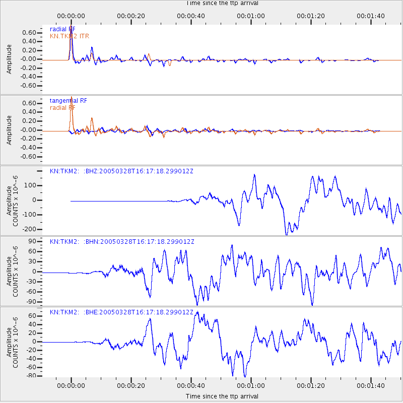
Earthquake location: Northern Sumatra, Indonesia
Earthquake latitude/longitude: 2.1/97.1
Earthquake time(UTC): 2005/03/28 (087) 16:09:36 GMT
Earthquake Depth: 30 km
Earthquake Magnitude: 7.2 MB, 8.4 MS, 8.7 MW, 8.1 MW
Earthquake Catalog/Contributor: WHDF/NEIC
Network: KN Kyrgyz Seismic Telemetry Network
Station: TKM2 KN.TKM2
Lat/Lon: 42.92 N/75.60 E
Elevation: 2020 m
Distance: 45.0 deg
Az: 337.596 deg
Baz: 148.768 deg
Ray Param: 0.071528554
Estimated Moho Depth: 44.0 km
Estimated Crust Vp/Vs: 1.95
Assumed Crust Vp: 6.306 km/s
Estimated Crust Vs: 3.234 km/s
Estimated Crust Poisson's Ratio: 0.32
Radial Match: 98.574776 %
Radial Bump: 339
Transverse Match: 95.461655 %
Transverse Bump: 400
SOD ConfigId: 2459
Insert Time: 2010-03-08 21:09:36.096 +0000
GWidth: 2.5
Max Bumps: 400
Tol: 0.001

Signal To Noise

ChannelStoNSTALTA
KN:TKM2: :BHN:20050328T16:17:18.299012Z5.7794551.1453661E-61.9817891E-7
KN:TKM2: :BHE:20050328T16:17:18.299012Z5.1382738.022197E-71.5612633E-7
KN:TKM2: :BHZ:20050328T16:17:18.299012Z4.98578022.0048726E-64.021181E-7
Arrivals
Ps7.0 SECOND
PpPs19 SECOND
PsPs/PpSs26 SECOND