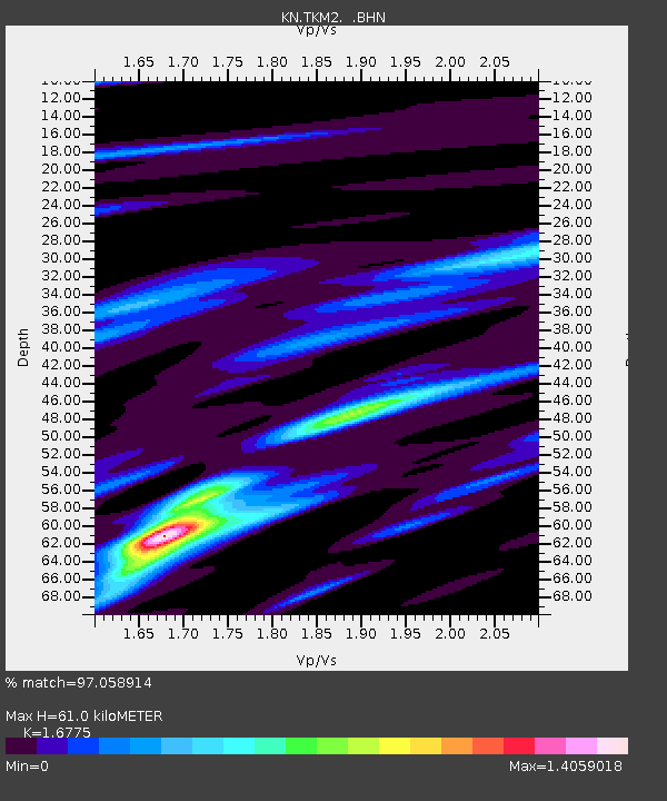
TKM2 KN.TKM2 - Earthquake Result Viewer
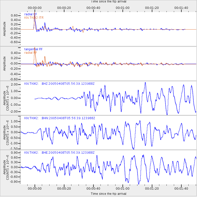
Earthquake location: Southwest Of Sumatra, Indonesia
Earthquake latitude/longitude: -0.2/97.7
Earthquake time(UTC): 2005/04/08 (098) 05:48:37 GMT
Earthquake Depth: 21 km
Earthquake Magnitude: 5.7 MB, 6.3 MS, 6.1 MW, 6.1 MW
Earthquake Catalog/Contributor: WHDF/NEIC
Network: KN Kyrgyz Seismic Telemetry Network
Station: TKM2 KN.TKM2
Lat/Lon: 42.92 N/75.60 E
Elevation: 2020 m
Distance: 47.3 deg
Az: 337.884 deg
Baz: 149.168 deg
Ray Param: 0.07003881
Estimated Moho Depth: 61.0 km
Estimated Crust Vp/Vs: 1.68
Assumed Crust Vp: 6.306 km/s
Estimated Crust Vs: 3.759 km/s
Estimated Crust Poisson's Ratio: 0.22
Radial Match: 97.058914 %
Radial Bump: 384
Transverse Match: 82.48676 %
Transverse Bump: 400
SOD ConfigId: 2459
Insert Time: 2010-03-08 21:09:44.968 +0000
GWidth: 2.5
Max Bumps: 400
Tol: 0.001

Signal To Noise

ChannelStoNSTALTA
KN:TKM2: :BHN:20050408T05:56:39.123988Z2.1980152.1186456E-79.6389044E-8
KN:TKM2: :BHE:20050408T05:56:39.123988Z2.87803671.2869071E-74.471476E-8
KN:TKM2: :BHZ:20050408T05:56:39.123988Z4.9242864.1177836E-78.362194E-8
Arrivals
Ps7.0 SECOND
PpPs24 SECOND
PsPs/PpSs31 SECOND