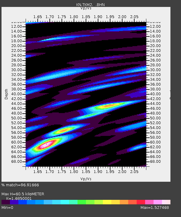
TKM2 KN.TKM2 - Earthquake Result Viewer
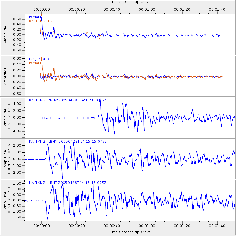
Earthquake location: Northern Sumatra, Indonesia
Earthquake latitude/longitude: 2.1/96.8
Earthquake time(UTC): 2005/04/28 (118) 14:07:33 GMT
Earthquake Depth: 22 km
Earthquake Magnitude: 5.9 MB, 6.2 MS, 6.3 MW, 6.2 MW
Earthquake Catalog/Contributor: WHDF/NEIC
Network: KN Kyrgyz Seismic Telemetry Network
Station: TKM2 KN.TKM2
Lat/Lon: 42.92 N/75.60 E
Elevation: 2020 m
Distance: 44.8 deg
Az: 337.854 deg
Baz: 149.148 deg
Ray Param: 0.0716566
Estimated Moho Depth: 60.5 km
Estimated Crust Vp/Vs: 1.69
Assumed Crust Vp: 6.306 km/s
Estimated Crust Vs: 3.742 km/s
Estimated Crust Poisson's Ratio: 0.23
Radial Match: 96.91666 %
Radial Bump: 400
Transverse Match: 91.50337 %
Transverse Bump: 400
SOD ConfigId: 2459
Insert Time: 2010-03-08 21:09:52.065 +0000
GWidth: 2.5
Max Bumps: 400
Tol: 0.001

Signal To Noise

ChannelStoNSTALTA
KN:TKM2: :BHN:20050428T14:15:15.075Z29.1834839.053372E-73.1022246E-8
KN:TKM2: :BHE:20050428T14:15:15.075Z22.9365376.6502895E-72.8994307E-8
KN:TKM2: :BHZ:20050428T14:15:15.075Z55.81562.0640584E-63.6979955E-8
Arrivals
Ps7.0 SECOND
PpPs24 SECOND
PsPs/PpSs31 SECOND