You are here: Home > Network List > TA - USArray Transportable Network (new EarthScope stations) Stations List
> Station F21K Alatna River, AK, USA > Earthquake Result Viewer
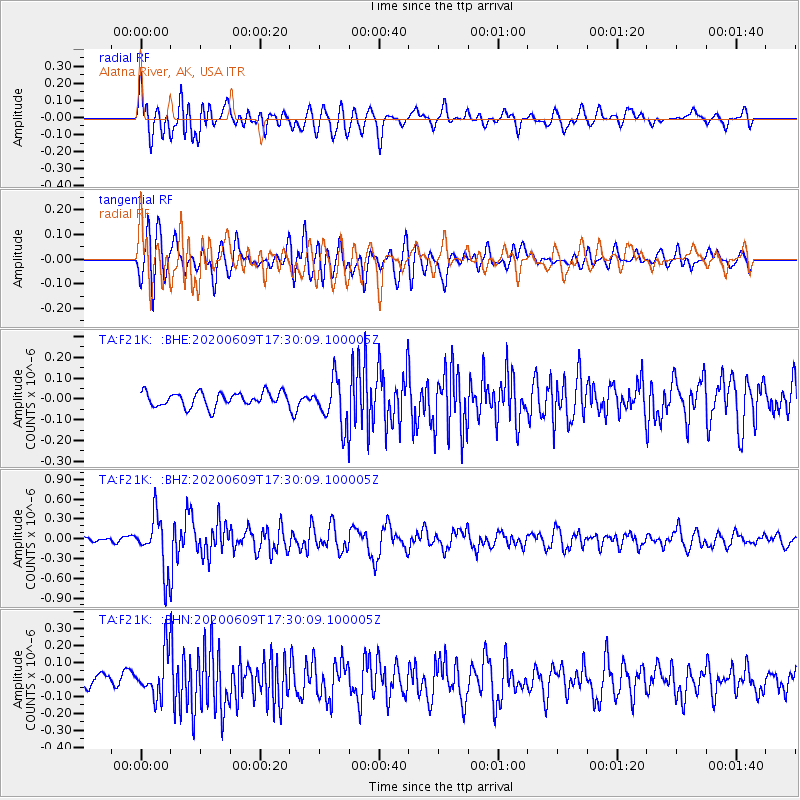
F21K Alatna River, AK, USA - Earthquake Result Viewer
*The percent match for this event was below the threshold and hence no stack was calculated.
| Earthquake location: |
Southern Iran |
| Earthquake latitude/longitude: |
27.7/53.4 |
| Earthquake time(UTC): |
2020/06/09 (161) 17:18:14 GMT |
| Earthquake Depth: |
10 km |
| Earthquake Magnitude: |
5.7 Mww |
| Earthquake Catalog/Contributor: |
NEIC PDE/us |
|
| Network: |
TA USArray Transportable Network (new EarthScope stations) |
| Station: |
F21K Alatna River, AK, USA |
| Lat/Lon: |
67.22 N/153.48 W |
| Elevation: |
597 m |
|
| Distance: |
83.2 deg |
| Az: |
10.225 deg |
| Baz: |
336.167 deg |
| Ray Param: |
$rayparam |
*The percent match for this event was below the threshold and hence was not used in the summary stack. |
|
| Radial Match: |
69.111916 % |
| Radial Bump: |
400 |
| Transverse Match: |
72.00743 % |
| Transverse Bump: |
400 |
| SOD ConfigId: |
21166931 |
| Insert Time: |
2020-06-23 17:30:33.288 +0000 |
| GWidth: |
2.5 |
| Max Bumps: |
400 |
| Tol: |
0.001 |
|
Signal To Noise
| Channel | StoN | STA | LTA |
| TA:F21K: :BHZ:20200609T17:30:09.100005Z | 8.754678 | 4.1427955E-7 | 4.732094E-8 |
| TA:F21K: :BHN:20200609T17:30:09.100005Z | 3.037608 | 1.2853417E-7 | 4.2314277E-8 |
| TA:F21K: :BHE:20200609T17:30:09.100005Z | 3.2458441 | 1.1100169E-7 | 3.4198095E-8 |
| Arrivals |
| Ps | |
| PpPs | |
| PsPs/PpSs | |


