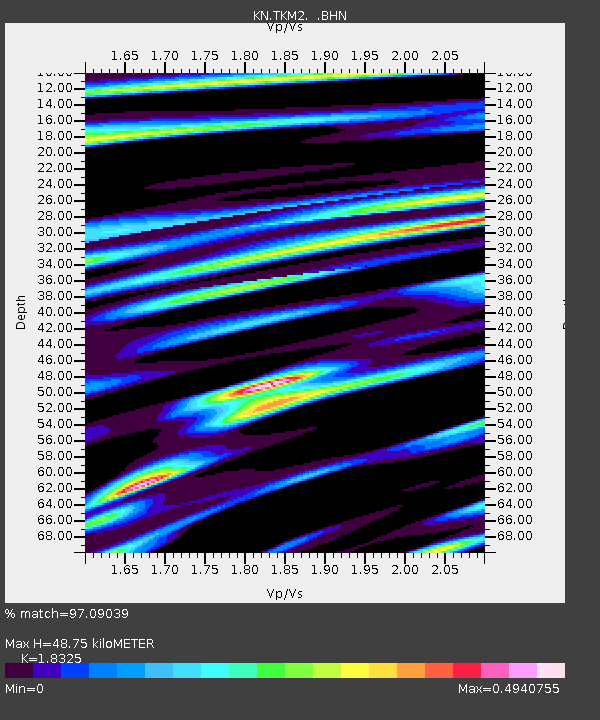
TKM2 KN.TKM2 - Earthquake Result Viewer
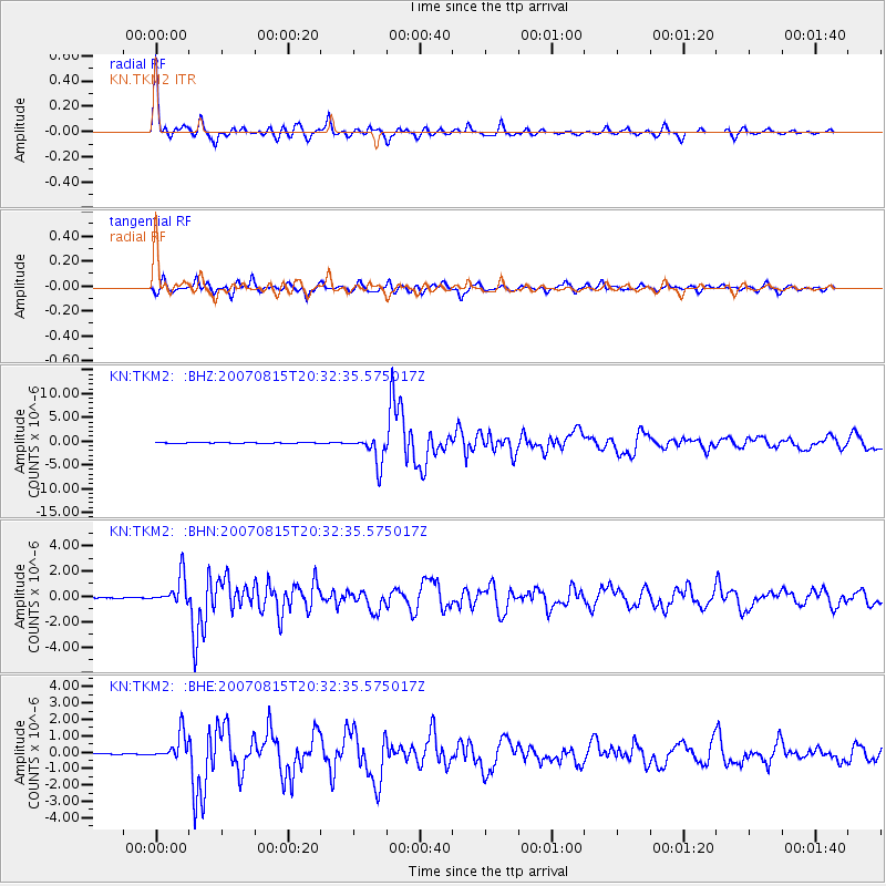
Earthquake location: Andreanof Islands, Aleutian Is.
Earthquake latitude/longitude: 50.3/-177.5
Earthquake time(UTC): 2007/08/15 (227) 20:22:11 GMT
Earthquake Depth: 9.0 km
Earthquake Magnitude: 6.3 MB, 6.2 MS, 6.4 MW, 5.9 ML
Earthquake Catalog/Contributor: WHDF/NEIC
Network: KN Kyrgyz Seismic Telemetry Network
Station: TKM2 KN.TKM2
Lat/Lon: 42.92 N/75.60 E
Elevation: 2020 m
Distance: 67.4 deg
Az: 310.405 deg
Baz: 41.643 deg
Ray Param: 0.056981917
Estimated Moho Depth: 48.75 km
Estimated Crust Vp/Vs: 1.83
Assumed Crust Vp: 6.306 km/s
Estimated Crust Vs: 3.441 km/s
Estimated Crust Poisson's Ratio: 0.29
Radial Match: 97.09039 %
Radial Bump: 362
Transverse Match: 90.89814 %
Transverse Bump: 400
SOD ConfigId: 2564
Insert Time: 2010-03-08 21:11:15.828 +0000
GWidth: 2.5
Max Bumps: 400
Tol: 0.001

Signal To Noise

ChannelStoNSTALTA
KN:TKM2: :BHN:20070815T20:32:35.575017Z47.4355851.1236839E-62.3688626E-8
KN:TKM2: :BHE:20070815T20:32:35.575017Z25.8620118.1218803E-73.1404674E-8
KN:TKM2: :BHZ:20070815T20:32:35.575017Z63.023882.978757E-64.7263942E-8
Arrivals
Ps6.7 SECOND
PpPs21 SECOND
PsPs/PpSs28 SECOND