You are here: Home > Network List > TA - USArray Transportable Network (new EarthScope stations) Stations List
> Station L15K Ungalak Mountain, AK, USA > Earthquake Result Viewer
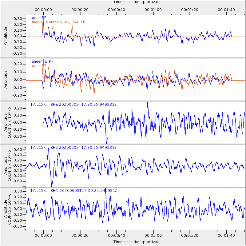
L15K Ungalak Mountain, AK, USA - Earthquake Result Viewer
*The percent match for this event was below the threshold and hence no stack was calculated.
| Earthquake location: |
Southern Iran |
| Earthquake latitude/longitude: |
27.7/53.4 |
| Earthquake time(UTC): |
2020/06/09 (161) 17:18:14 GMT |
| Earthquake Depth: |
10 km |
| Earthquake Magnitude: |
5.7 Mww |
| Earthquake Catalog/Contributor: |
NEIC PDE/us |
|
| Network: |
TA USArray Transportable Network (new EarthScope stations) |
| Station: |
L15K Ungalak Mountain, AK, USA |
| Lat/Lon: |
61.68 N/161.49 W |
| Elevation: |
219 m |
|
| Distance: |
86.5 deg |
| Az: |
15.871 deg |
| Baz: |
329.45 deg |
| Ray Param: |
$rayparam |
*The percent match for this event was below the threshold and hence was not used in the summary stack. |
|
| Radial Match: |
66.74872 % |
| Radial Bump: |
400 |
| Transverse Match: |
59.773502 % |
| Transverse Bump: |
400 |
| SOD ConfigId: |
21166931 |
| Insert Time: |
2020-06-23 17:31:31.746 +0000 |
| GWidth: |
2.5 |
| Max Bumps: |
400 |
| Tol: |
0.001 |
|
Signal To Noise
| Channel | StoN | STA | LTA |
| TA:L15K: :BHZ:20200609T17:30:25.949981Z | 3.8709116 | 3.56268E-7 | 9.203724E-8 |
| TA:L15K: :BHN:20200609T17:30:25.949981Z | 1.7957314 | 1.2334249E-7 | 6.86865E-8 |
| TA:L15K: :BHE:20200609T17:30:25.949981Z | 1.8085703 | 1.10179975E-7 | 6.092104E-8 |
| Arrivals |
| Ps | |
| PpPs | |
| PsPs/PpSs | |


