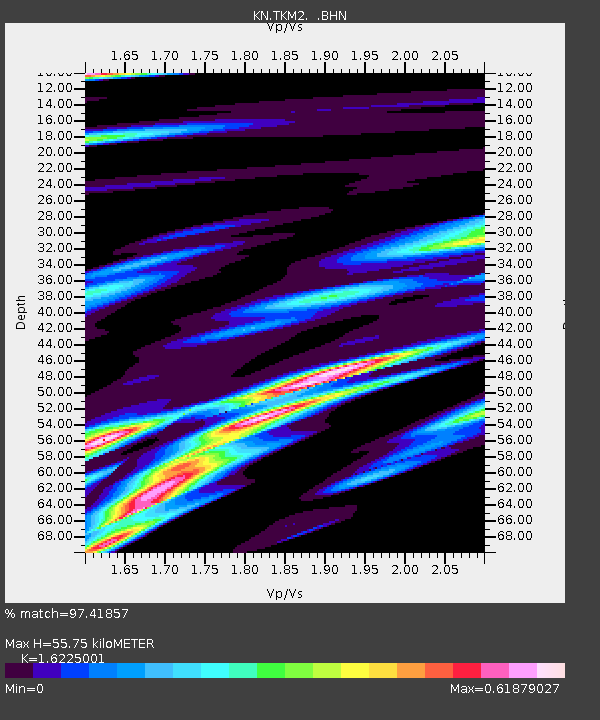
TKM2 KN.TKM2 - Earthquake Result Viewer
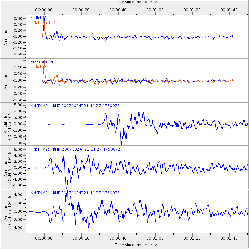
Earthquake location: Southern Sumatra, Indonesia
Earthquake latitude/longitude: -3.9/101.0
Earthquake time(UTC): 2007/10/24 (297) 21:02:50 GMT
Earthquake Depth: 20 km
Earthquake Magnitude: 6.1 MB, 6.9 MS, 6.8 MW, 6.3 ME
Earthquake Catalog/Contributor: WHDF/NEIC
Network: KN Kyrgyz Seismic Telemetry Network
Station: TKM2 KN.TKM2
Lat/Lon: 42.92 N/75.60 E
Elevation: 2020 m
Distance: 52.0 deg
Az: 336.401 deg
Baz: 147.061 deg
Ray Param: 0.06704087
Estimated Moho Depth: 55.75 km
Estimated Crust Vp/Vs: 1.62
Assumed Crust Vp: 6.306 km/s
Estimated Crust Vs: 3.887 km/s
Estimated Crust Poisson's Ratio: 0.19
Radial Match: 97.41857 %
Radial Bump: 400
Transverse Match: 91.02699 %
Transverse Bump: 400
SOD ConfigId: 2564
Insert Time: 2010-03-08 21:12:46.448 +0000
GWidth: 2.5
Max Bumps: 400
Tol: 0.001

Signal To Noise

ChannelStoNSTALTA
KN:TKM2: :BHN:20071024T21:11:27.175007Z28.2711351.5050714E-65.3237038E-8
KN:TKM2: :BHE:20071024T21:11:27.175007Z22.7595211.1974691E-65.261399E-8
KN:TKM2: :BHZ:20071024T21:11:27.175007Z50.2903143.6856711E-67.328789E-8
Arrivals
Ps5.8 SECOND
PpPs22 SECOND
PsPs/PpSs28 SECOND