You are here: Home > Network List > IU - Global Seismograph Network (GSN - IRIS/USGS) Stations List
> Station JOHN Johnston Island, USA > Earthquake Result Viewer
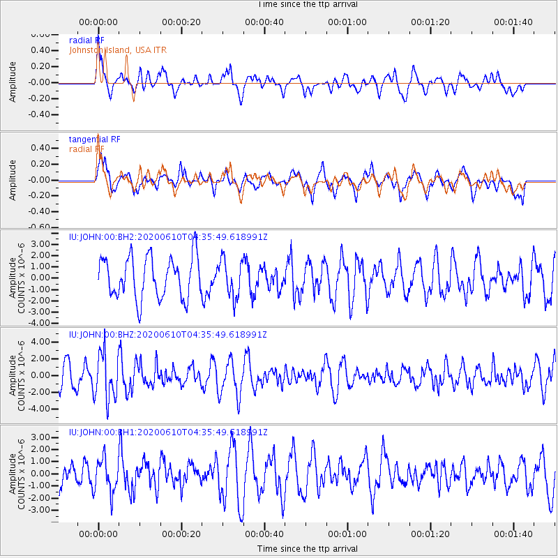
JOHN Johnston Island, USA - Earthquake Result Viewer
*The percent match for this event was below the threshold and hence no stack was calculated.
| Earthquake location: |
South Of Fiji Islands |
| Earthquake latitude/longitude: |
-23.5/179.2 |
| Earthquake time(UTC): |
2020/06/10 (162) 04:29:20 GMT |
| Earthquake Depth: |
539 km |
| Earthquake Magnitude: |
5.9 Mww |
| Earthquake Catalog/Contributor: |
NEIC PDE/us |
|
| Network: |
IU Global Seismograph Network (GSN - IRIS/USGS) |
| Station: |
JOHN Johnston Island, USA |
| Lat/Lon: |
16.73 N/169.53 W |
| Elevation: |
2.0 m |
|
| Distance: |
41.5 deg |
| Az: |
16.389 deg |
| Baz: |
195.683 deg |
| Ray Param: |
$rayparam |
*The percent match for this event was below the threshold and hence was not used in the summary stack. |
|
| Radial Match: |
60.58314 % |
| Radial Bump: |
400 |
| Transverse Match: |
55.46132 % |
| Transverse Bump: |
400 |
| SOD ConfigId: |
21166931 |
| Insert Time: |
2020-06-24 04:39:53.916 +0000 |
| GWidth: |
2.5 |
| Max Bumps: |
400 |
| Tol: |
0.001 |
|
Signal To Noise
| Channel | StoN | STA | LTA |
| IU:JOHN:00:BHZ:20200610T04:35:49.618991Z | 2.408919 | 2.842831E-6 | 1.1801271E-6 |
| IU:JOHN:00:BH1:20200610T04:35:49.618991Z | 1.304928 | 1.3822438E-6 | 1.0592491E-6 |
| IU:JOHN:00:BH2:20200610T04:35:49.618991Z | 0.9127525 | 1.6586024E-6 | 1.8171436E-6 |
| Arrivals |
| Ps | |
| PpPs | |
| PsPs/PpSs | |


