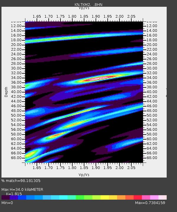
TKM2 KN.TKM2 - Earthquake Result Viewer
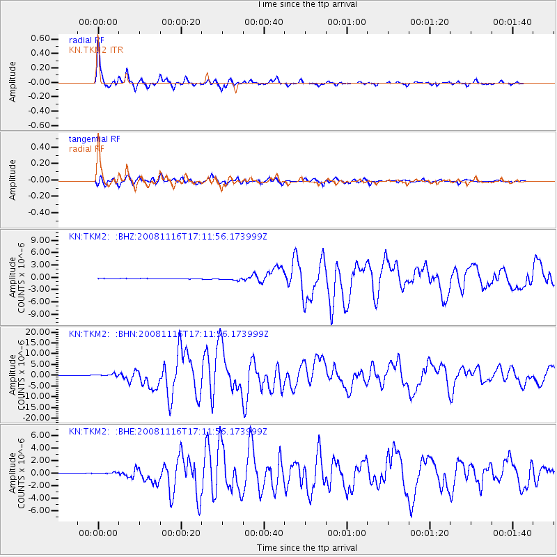
Earthquake location: Minahassa Peninsula, Sulawesi
Earthquake latitude/longitude: 1.3/122.1
Earthquake time(UTC): 2008/11/16 (321) 17:02:32 GMT
Earthquake Depth: 30 km
Earthquake Magnitude: 6.5 MB, 7.0 MS, 7.3 MW, 7.3 MW
Earthquake Catalog/Contributor: WHDF/NEIC
Network: KN Kyrgyz Seismic Telemetry Network
Station: TKM2 KN.TKM2
Lat/Lon: 42.92 N/75.60 E
Elevation: 2020 m
Distance: 58.6 deg
Az: 321.392 deg
Baz: 121.87 deg
Ray Param: 0.062668286
Estimated Moho Depth: 34.0 km
Estimated Crust Vp/Vs: 1.91
Assumed Crust Vp: 6.306 km/s
Estimated Crust Vs: 3.293 km/s
Estimated Crust Poisson's Ratio: 0.31
Radial Match: 98.181305 %
Radial Bump: 299
Transverse Match: 90.747734 %
Transverse Bump: 400
SOD ConfigId: 2658
Insert Time: 2010-03-08 21:12:56.697 +0000
GWidth: 2.5
Max Bumps: 400
Tol: 0.001

Signal To Noise

ChannelStoNSTALTA
KN:TKM2: :BHN:20081116T17:11:56.173999Z6.7568315.9608016E-78.821889E-8
KN:TKM2: :BHE:20081116T17:11:56.173999Z2.08218072.6074684E-71.2522776E-7
KN:TKM2: :BHZ:20081116T17:11:56.173999Z4.81086062.7752873E-75.7687963E-8
Arrivals
Ps5.2 SECOND
PpPs15 SECOND
PsPs/PpSs20 SECOND