You are here: Home > Network List > TA - USArray Transportable Network (new EarthScope stations) Stations List
> Station C16K Lisburne Hills, AK, USA > Earthquake Result Viewer
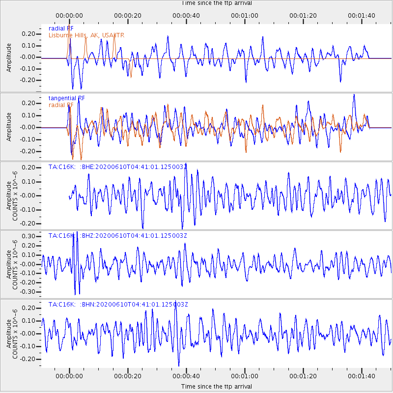
C16K Lisburne Hills, AK, USA - Earthquake Result Viewer
*The percent match for this event was below the threshold and hence no stack was calculated.
| Earthquake location: |
South Of Fiji Islands |
| Earthquake latitude/longitude: |
-23.5/179.2 |
| Earthquake time(UTC): |
2020/06/10 (162) 04:29:20 GMT |
| Earthquake Depth: |
539 km |
| Earthquake Magnitude: |
5.9 Mww |
| Earthquake Catalog/Contributor: |
NEIC PDE/us |
|
| Network: |
TA USArray Transportable Network (new EarthScope stations) |
| Station: |
C16K Lisburne Hills, AK, USA |
| Lat/Lon: |
68.27 N/165.34 W |
| Elevation: |
102 m |
|
| Distance: |
92.2 deg |
| Az: |
5.69 deg |
| Baz: |
194.15 deg |
| Ray Param: |
$rayparam |
*The percent match for this event was below the threshold and hence was not used in the summary stack. |
|
| Radial Match: |
55.298958 % |
| Radial Bump: |
400 |
| Transverse Match: |
59.561844 % |
| Transverse Bump: |
400 |
| SOD ConfigId: |
21166931 |
| Insert Time: |
2020-06-24 04:42:38.611 +0000 |
| GWidth: |
2.5 |
| Max Bumps: |
400 |
| Tol: |
0.001 |
|
Signal To Noise
| Channel | StoN | STA | LTA |
| TA:C16K: :BHZ:20200610T04:41:01.125003Z | 2.853948 | 1.6687419E-7 | 5.8471347E-8 |
| TA:C16K: :BHN:20200610T04:41:01.125003Z | 0.9462915 | 7.356373E-8 | 7.7738974E-8 |
| TA:C16K: :BHE:20200610T04:41:01.125003Z | 0.9204415 | 5.9001874E-8 | 6.410171E-8 |
| Arrivals |
| Ps | |
| PpPs | |
| PsPs/PpSs | |


