You are here: Home > Network List > TJ - Tajikistan National Seismic Network Stations List
> Station MANEM Manem, Tajikistan > Earthquake Result Viewer
MANEM Manem, Tajikistan - Earthquake Result Viewer
| Earthquake location: |
Southern Sumatra, Indonesia |
| Earthquake latitude/longitude: |
-2.6/101.2 |
| Earthquake time(UTC): |
2020/06/10 (162) 04:35:18 GMT |
| Earthquake Depth: |
39 km |
| Earthquake Magnitude: |
5.0 Mww |
| Earthquake Catalog/Contributor: |
NEIC PDE/us |
|
| Network: |
TJ Tajikistan National Seismic Network |
| Station: |
MANEM Manem, Tajikistan |
| Lat/Lon: |
37.53 N/71.66 E |
| Elevation: |
2312 m |
|
| Distance: |
48.4 deg |
| Az: |
328.422 deg |
| Baz: |
138.85 deg |
| Ray Param: |
0.069324024 |
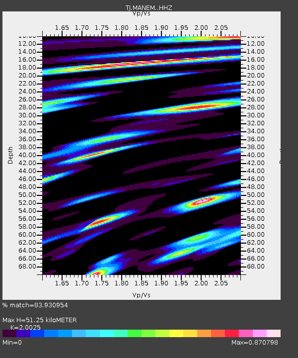
| Estimated Moho Depth: |
51.25 km |
| Estimated Crust Vp/Vs: |
2.00 |
| Assumed Crust Vp: |
6.306 km/s |
| Estimated Crust Vs: |
3.149 km/s |
| Estimated Crust Poisson's Ratio: |
0.33 |
|
| Radial Match: |
83.930954 % |
| Radial Bump: |
400 |
| Transverse Match: |
75.70361 % |
| Transverse Bump: |
400 |
| SOD ConfigId: |
21166931 |
| Insert Time: |
2020-06-24 04:53:00.127 +0000 |
| GWidth: |
2.5 |
| Max Bumps: |
400 |
| Tol: |
0.001 |
|

Signal To Noise
| Channel | StoN | STA | LTA |
| TJ:MANEM: :HHZ:20200610T04:43:26.099993Z | 13.185625 | 1.454092E-6 | 1.1027857E-7 |
| TJ:MANEM: :HHN:20200610T04:43:26.099993Z | 7.7312307 | 6.542476E-7 | 8.4623984E-8 |
| TJ:MANEM: :HHE:20200610T04:43:26.099993Z | 7.1546807 | 6.151314E-7 | 8.5976076E-8 |
| Arrivals |
| Ps | 8.6 SECOND |
| PpPs | 23 SECOND |
| PsPs/PpSs | 32 SECOND |


