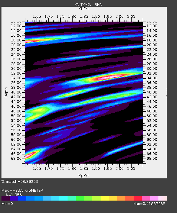
TKM2 KN.TKM2 - Earthquake Result Viewer
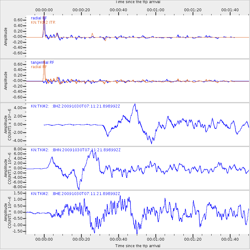
Earthquake location: Ryukyu Islands, Japan
Earthquake latitude/longitude: 29.2/129.8
Earthquake time(UTC): 2009/10/30 (303) 07:03:39 GMT
Earthquake Depth: 34 km
Earthquake Magnitude: 6.3 MB, 6.8 MS, 6.8 MW, 6.8 MW
Earthquake Catalog/Contributor: WHDF/NEIC
Network: KN Kyrgyz Seismic Telemetry Network
Station: TKM2 KN.TKM2
Lat/Lon: 42.92 N/75.60 E
Elevation: 2020 m
Distance: 45.1 deg
Az: 302.835 deg
Baz: 89.22 deg
Ray Param: 0.07139825
Estimated Moho Depth: 33.5 km
Estimated Crust Vp/Vs: 1.96
Assumed Crust Vp: 6.306 km/s
Estimated Crust Vs: 3.226 km/s
Estimated Crust Poisson's Ratio: 0.32
Radial Match: 98.36253 %
Radial Bump: 338
Transverse Match: 94.34003 %
Transverse Bump: 400
SOD ConfigId: 2622
Insert Time: 2010-03-08 21:13:58.990 +0000
GWidth: 2.5
Max Bumps: 400
Tol: 0.001

Signal To Noise

ChannelStoNSTALTA
KN:TKM2: :BHN:20091030T07:11:21.898992Z34.2371832.3642037E-66.9053684E-8
KN:TKM2: :BHE:20091030T07:11:21.898992Z1.78977871.2781199E-77.1412174E-8
KN:TKM2: :BHZ:20091030T07:11:21.898992Z19.0329461.3368682E-67.0239686E-8
Arrivals
Ps5.4 SECOND
PpPs15 SECOND
PsPs/PpSs20 SECOND