You are here: Home > Network List > G - GEOSCOPE Stations List
> Station MPG Montagne des Peres, French Guyana > Earthquake Result Viewer
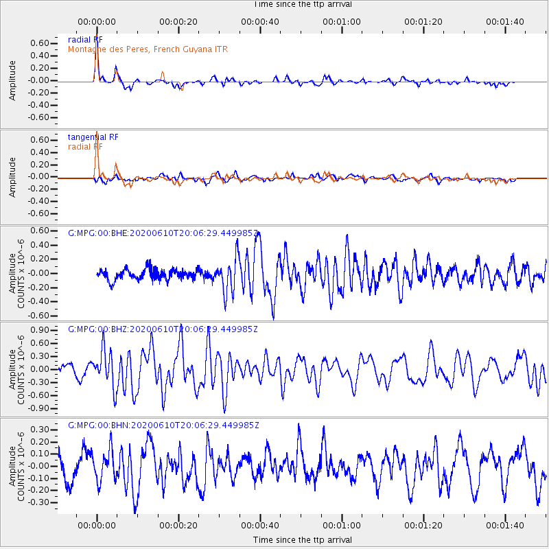
MPG Montagne des Peres, French Guyana - Earthquake Result Viewer
*The percent match for this event was below the threshold and hence no stack was calculated.
| Earthquake location: |
Southern Mid-Atlantic Ridge |
| Earthquake latitude/longitude: |
-15.8/-13.0 |
| Earthquake time(UTC): |
2020/06/10 (162) 19:58:50 GMT |
| Earthquake Depth: |
10 km |
| Earthquake Magnitude: |
6.0 Mww |
| Earthquake Catalog/Contributor: |
NEIC PDE/us |
|
| Network: |
G GEOSCOPE |
| Station: |
MPG Montagne des Peres, French Guyana |
| Lat/Lon: |
5.11 N/52.64 W |
| Elevation: |
147 m |
|
| Distance: |
44.3 deg |
| Az: |
294.738 deg |
| Baz: |
118.609 deg |
| Ray Param: |
$rayparam |
*The percent match for this event was below the threshold and hence was not used in the summary stack. |
|
| Radial Match: |
72.72129 % |
| Radial Bump: |
332 |
| Transverse Match: |
60.60352 % |
| Transverse Bump: |
400 |
| SOD ConfigId: |
21709731 |
| Insert Time: |
2020-06-24 20:04:12.858 +0000 |
| GWidth: |
2.5 |
| Max Bumps: |
400 |
| Tol: |
0.001 |
|
Signal To Noise
| Channel | StoN | STA | LTA |
| G:MPG:00:BHZ:20200610T20:06:29.449985Z | 4.0717635 | 4.3425052E-7 | 1.0664925E-7 |
| G:MPG:00:BHN:20200610T20:06:29.449985Z | 1.0951242 | 1.2693035E-7 | 1.15904975E-7 |
| G:MPG:00:BHE:20200610T20:06:29.449985Z | 3.317592 | 2.456158E-7 | 7.403436E-8 |
| Arrivals |
| Ps | |
| PpPs | |
| PsPs/PpSs | |


