You are here: Home > Network List > KN - Kyrgyz Seismic Telemetry Network Stations List
> Station TKM2 KN.TKM2 > Earthquake Result Viewer
TKM2 KN.TKM2 - Earthquake Result Viewer
*The percent match for this event was below the threshold and hence no stack was calculated.
| Earthquake location: |
Banda Sea |
| Earthquake latitude/longitude: |
-7.5/127.8 |
| Earthquake time(UTC): |
2009/02/26 (057) 21:09:30 GMT |
| Earthquake Depth: |
145 km |
| Earthquake Magnitude: |
5.5 MW, 5.4 MB, 5.5 MW |
| Earthquake Catalog/Contributor: |
WHDF/NEIC |
|
| Network: |
KN Kyrgyz Seismic Telemetry Network |
| Station: |
TKM2 KN.TKM2 |
| Lat/Lon: |
42.92 N/75.60 E |
| Elevation: |
2020 m |
|
| Distance: |
69.0 deg |
| Az: |
321.559 deg |
| Baz: |
122.938 deg |
| Ray Param: |
$rayparam |
*The percent match for this event was below the threshold and hence was not used in the summary stack. |
|
| Radial Match: |
33.44429 % |
| Radial Bump: |
400 |
| Transverse Match: |
38.330994 % |
| Transverse Bump: |
400 |
| SOD ConfigId: |
2658 |
| Insert Time: |
2010-03-08 21:14:09.348 +0000 |
| GWidth: |
2.5 |
| Max Bumps: |
400 |
| Tol: |
0.001 |
|
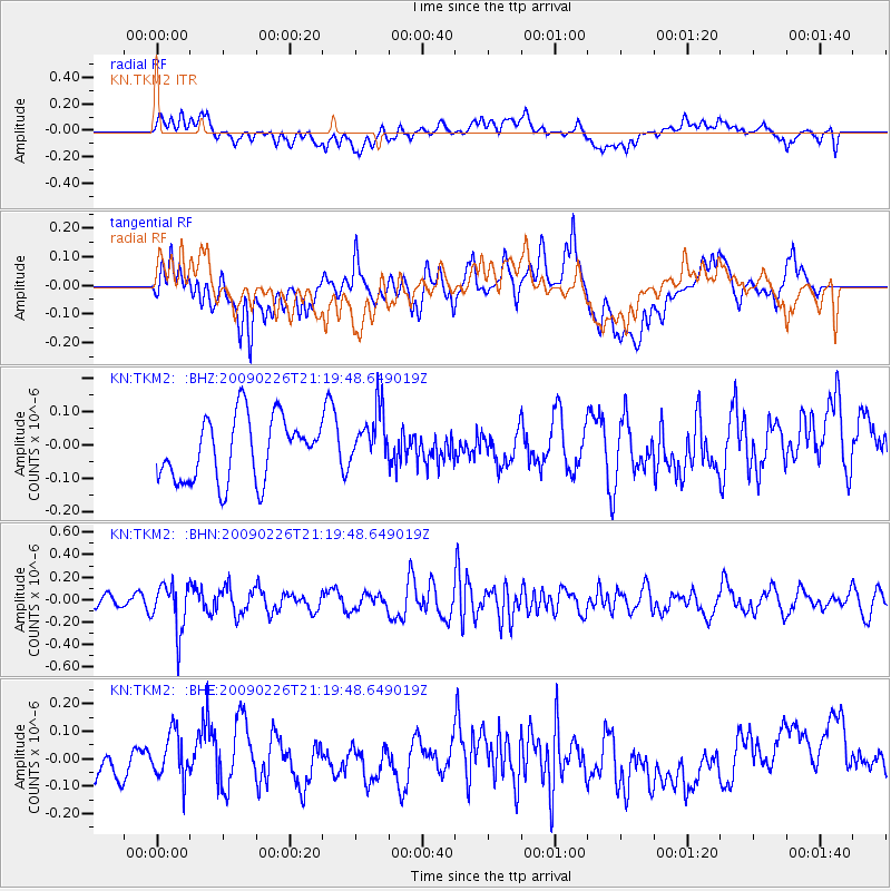
Signal To Noise
| Channel | StoN | STA | LTA |
| KN:TKM2: :BHN:20090226T21:19:48.649019Z | 3.650898 | 2.110891E-7 | 5.7818408E-8 |
| KN:TKM2: :BHE:20090226T21:19:48.649019Z | 0.9757297 | 9.022923E-8 | 9.247359E-8 |
| KN:TKM2: :BHZ:20090226T21:19:48.649019Z | 0.910475 | 8.5468606E-8 | 9.387254E-8 |
| Arrivals |
| Ps | |
| PpPs | |
| PsPs/PpSs | |


