You are here: Home > Network List > KN - Kyrgyz Seismic Telemetry Network Stations List
> Station TKM2 KN.TKM2 > Earthquake Result Viewer
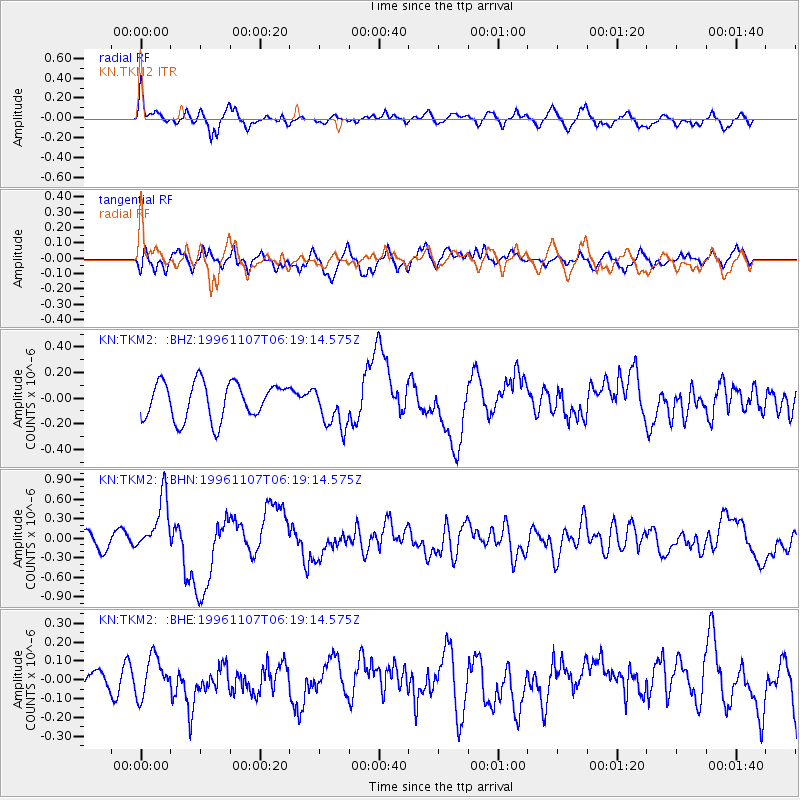
TKM2 KN.TKM2 - Earthquake Result Viewer
*The percent match for this event was below the threshold and hence no stack was calculated.
| Earthquake location: |
Mindanao, Philippines |
| Earthquake latitude/longitude: |
9.8/126.3 |
| Earthquake time(UTC): |
1996/11/07 (312) 06:10:16 GMT |
| Earthquake Depth: |
33 km |
| Earthquake Magnitude: |
5.7 MB, 6.0 MS, 6.1 UNKNOWN, 6.0 MW |
| Earthquake Catalog/Contributor: |
WHDF/NEIC |
|
| Network: |
KN Kyrgyz Seismic Telemetry Network |
| Station: |
TKM2 KN.TKM2 |
| Lat/Lon: |
42.92 N/75.60 E |
| Elevation: |
2020 m |
|
| Distance: |
55.1 deg |
| Az: |
316.063 deg |
| Baz: |
111.405 deg |
| Ray Param: |
$rayparam |
*The percent match for this event was below the threshold and hence was not used in the summary stack. |
|
| Radial Match: |
73.03272 % |
| Radial Bump: |
400 |
| Transverse Match: |
69.36801 % |
| Transverse Bump: |
400 |
| SOD ConfigId: |
4480 |
| Insert Time: |
2010-03-08 21:14:12.440 +0000 |
| GWidth: |
2.5 |
| Max Bumps: |
400 |
| Tol: |
0.001 |
|
Signal To Noise
| Channel | StoN | STA | LTA |
| KN:TKM2: :BHN:19961107T06:19:14.575Z | 4.584906 | 4.2335316E-7 | 9.233628E-8 |
| KN:TKM2: :BHE:19961107T06:19:14.575Z | 1.247846 | 1.02347286E-7 | 8.201917E-8 |
| KN:TKM2: :BHZ:19961107T06:19:14.575Z | 1.1857994 | 1.6908636E-7 | 1.4259273E-7 |
| Arrivals |
| Ps | |
| PpPs | |
| PsPs/PpSs | |


