You are here: Home > Network List > KN - Kyrgyz Seismic Telemetry Network Stations List
> Station TKM2 KN.TKM2 > Earthquake Result Viewer
TKM2 KN.TKM2 - Earthquake Result Viewer
*The percent match for this event was below the threshold and hence no stack was calculated.
| Earthquake location: |
Eastern New Guinea Reg., P.N.G. |
| Earthquake latitude/longitude: |
-6.3/147.9 |
| Earthquake time(UTC): |
1996/03/17 (077) 17:58:20 GMT |
| Earthquake Depth: |
33 km |
| Earthquake Magnitude: |
5.5 MB, 6.0 MS, 6.1 UNKNOWN, 6.2 ML |
| Earthquake Catalog/Contributor: |
WHDF/NEIC |
|
| Network: |
KN Kyrgyz Seismic Telemetry Network |
| Station: |
TKM2 KN.TKM2 |
| Lat/Lon: |
42.92 N/75.60 E |
| Elevation: |
2020 m |
|
| Distance: |
81.5 deg |
| Az: |
314.956 deg |
| Baz: |
106.73 deg |
| Ray Param: |
$rayparam |
*The percent match for this event was below the threshold and hence was not used in the summary stack. |
|
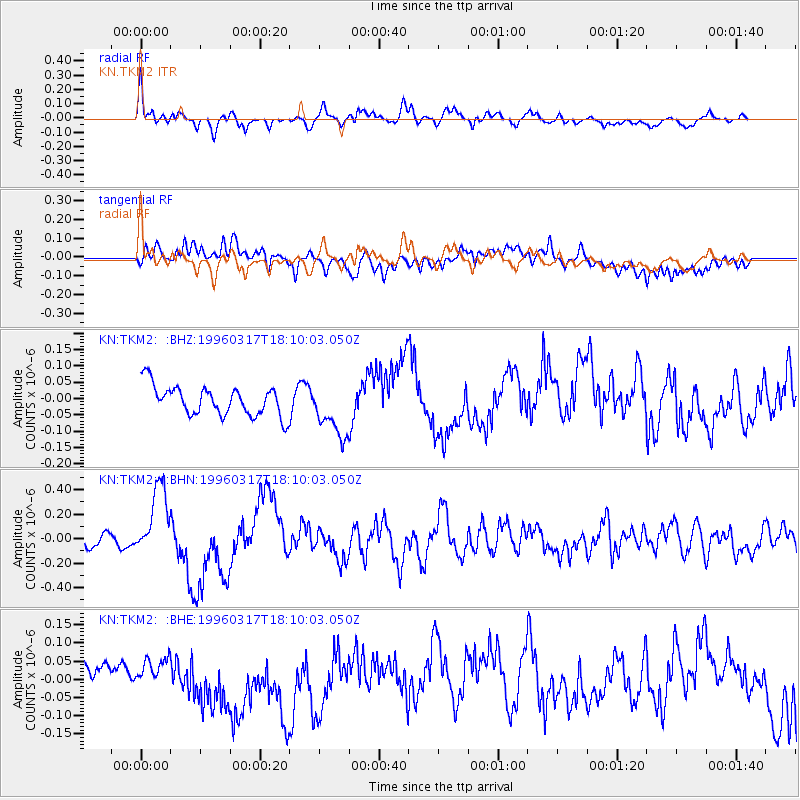
| Radial Match: |
76.63328 % |
| Radial Bump: |
400 |
| Transverse Match: |
68.44578 % |
| Transverse Bump: |
400 |
| SOD ConfigId: |
4480 |
| Insert Time: |
2010-03-08 21:14:14.972 +0000 |
| GWidth: |
2.5 |
| Max Bumps: |
400 |
| Tol: |
0.001 |
|
Signal To Noise
| Channel | StoN | STA | LTA |
| KN:TKM2: :BHN:19960317T18:10:03.050Z | 7.5379543 | 2.9447793E-7 | 3.9066027E-8 |
| KN:TKM2: :BHE:19960317T18:10:03.050Z | 1.1562897 | 4.335873E-8 | 3.7498157E-8 |
| KN:TKM2: :BHZ:19960317T18:10:03.050Z | 1.8085164 | 8.216279E-8 | 4.5431047E-8 |
| Arrivals |
| Ps | |
| PpPs | |
| PsPs/PpSs | |


