You are here: Home > Network List > KN - Kyrgyz Seismic Telemetry Network Stations List
> Station TKM2 KN.TKM2 > Earthquake Result Viewer
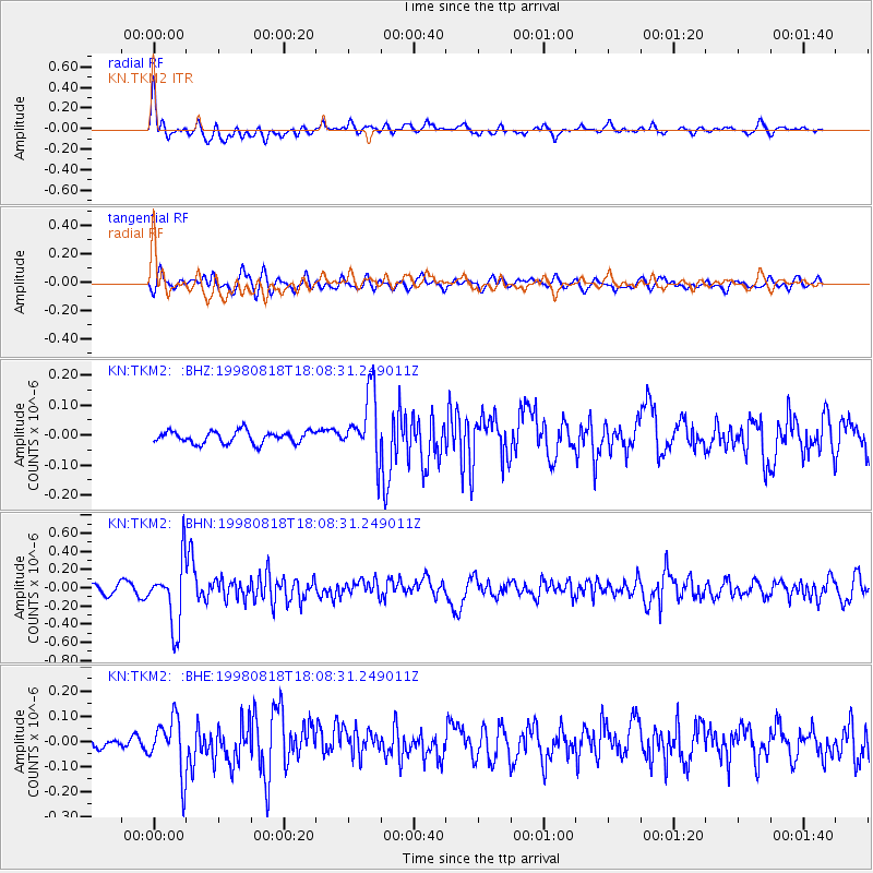
TKM2 KN.TKM2 - Earthquake Result Viewer
*The percent match for this event was below the threshold and hence no stack was calculated.
| Earthquake location: |
Kuril Islands |
| Earthquake latitude/longitude: |
45.9/149.1 |
| Earthquake time(UTC): |
1998/08/18 (230) 18:00:12 GMT |
| Earthquake Depth: |
116 km |
| Earthquake Magnitude: |
5.6 UNKNOWN, 5.4 MB, 5.6 MW |
| Earthquake Catalog/Contributor: |
WHDF/NEIC |
|
| Network: |
KN Kyrgyz Seismic Telemetry Network |
| Station: |
TKM2 KN.TKM2 |
| Lat/Lon: |
42.92 N/75.60 E |
| Elevation: |
2020 m |
|
| Distance: |
50.9 deg |
| Az: |
294.781 deg |
| Baz: |
59.751 deg |
| Ray Param: |
$rayparam |
*The percent match for this event was below the threshold and hence was not used in the summary stack. |
|
| Radial Match: |
74.031006 % |
| Radial Bump: |
400 |
| Transverse Match: |
60.94814 % |
| Transverse Bump: |
400 |
| SOD ConfigId: |
4480 |
| Insert Time: |
2010-03-08 21:14:15.687 +0000 |
| GWidth: |
2.5 |
| Max Bumps: |
400 |
| Tol: |
0.001 |
|
Signal To Noise
| Channel | StoN | STA | LTA |
| KN:TKM2: :BHN:19980818T18:08:31.249011Z | 8.420255 | 3.555185E-7 | 4.2221824E-8 |
| KN:TKM2: :BHE:19980818T18:08:31.249011Z | 4.9981074 | 1.0874568E-7 | 2.1757371E-8 |
| KN:TKM2: :BHZ:19980818T18:08:31.249011Z | 5.4601016 | 1.0979764E-7 | 2.0109082E-8 |
| Arrivals |
| Ps | |
| PpPs | |
| PsPs/PpSs | |


