You are here: Home > Network List > KO - Kandilli Observatory Digital Broadband Seismic Network Stations List
> Station ELL Elmali-Antalya-Turkey > Earthquake Result Viewer
ELL Elmali-Antalya-Turkey - Earthquake Result Viewer
| Earthquake location: |
Southern Mid-Atlantic Ridge |
| Earthquake latitude/longitude: |
-15.8/-13.0 |
| Earthquake time(UTC): |
2020/06/10 (162) 19:58:50 GMT |
| Earthquake Depth: |
10 km |
| Earthquake Magnitude: |
6.0 Mww |
| Earthquake Catalog/Contributor: |
NEIC PDE/us |
|
| Network: |
KO Kandilli Observatory Digital Broadband Seismic Network |
| Station: |
ELL Elmali-Antalya-Turkey |
| Lat/Lon: |
36.75 N/29.91 E |
| Elevation: |
1230 m |
|
| Distance: |
66.1 deg |
| Az: |
36.772 deg |
| Baz: |
225.857 deg |
| Ray Param: |
0.057838384 |
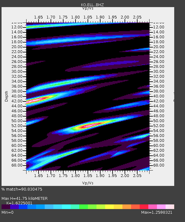
| Estimated Moho Depth: |
41.75 km |
| Estimated Crust Vp/Vs: |
1.62 |
| Assumed Crust Vp: |
6.12 km/s |
| Estimated Crust Vs: |
3.772 km/s |
| Estimated Crust Poisson's Ratio: |
0.19 |
|
| Radial Match: |
90.830475 % |
| Radial Bump: |
363 |
| Transverse Match: |
80.91231 % |
| Transverse Bump: |
400 |
| SOD ConfigId: |
21709731 |
| Insert Time: |
2020-06-24 20:06:29.111 +0000 |
| GWidth: |
2.5 |
| Max Bumps: |
400 |
| Tol: |
0.001 |
|

Signal To Noise
| Channel | StoN | STA | LTA |
| KO:ELL: :BHZ:20200610T20:09:06.060001Z | 1.8789569 | 3.441656E-7 | 1.8316845E-7 |
| KO:ELL: :BHN:20200610T20:09:06.060001Z | 0.9358185 | 1.691835E-7 | 1.8078666E-7 |
| KO:ELL: :BHE:20200610T20:09:06.060001Z | 1.4254725 | 2.1433077E-7 | 1.5035769E-7 |
| Arrivals |
| Ps | 4.4 SECOND |
| PpPs | 17 SECOND |
| PsPs/PpSs | 22 SECOND |


