You are here: Home > Network List > KN - Kyrgyz Seismic Telemetry Network Stations List
> Station TKM2 KN.TKM2 > Earthquake Result Viewer
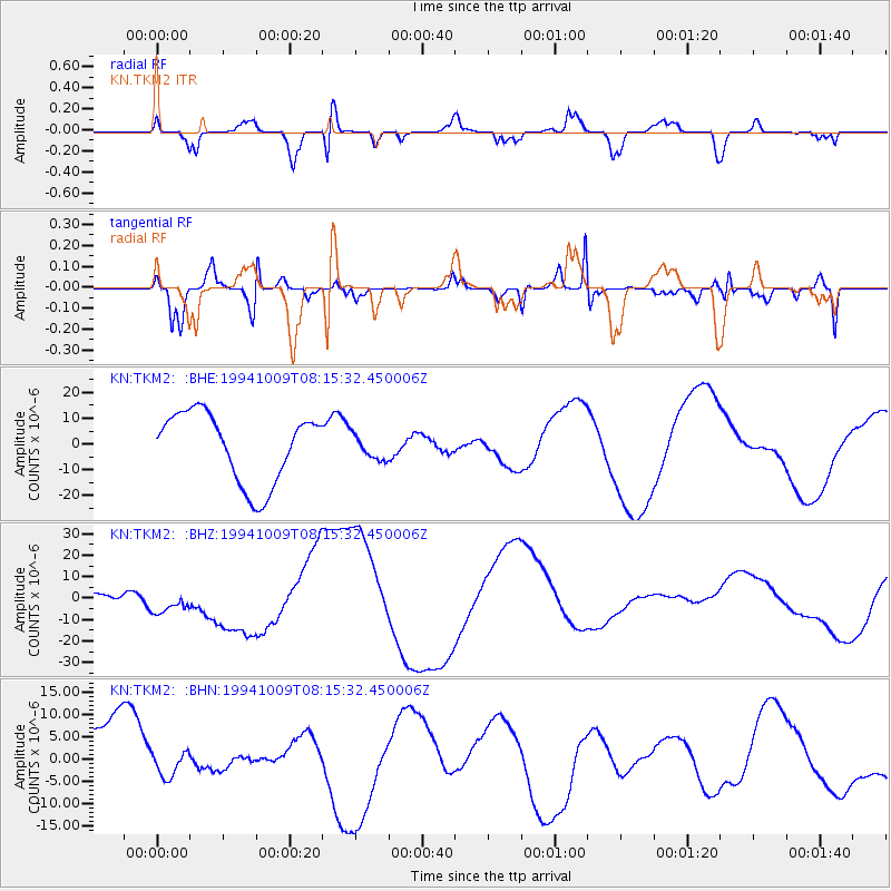
TKM2 KN.TKM2 - Earthquake Result Viewer
*The percent match for this event was below the threshold and hence no stack was calculated.
| Earthquake location: |
East Of Kuril Islands |
| Earthquake latitude/longitude: |
43.7/148.0 |
| Earthquake time(UTC): |
1994/10/09 (282) 08:07:04 GMT |
| Earthquake Depth: |
42 km |
| Earthquake Magnitude: |
5.9 MB |
| Earthquake Catalog/Contributor: |
WHDF/NEIC |
|
| Network: |
KN Kyrgyz Seismic Telemetry Network |
| Station: |
TKM2 KN.TKM2 |
| Lat/Lon: |
42.92 N/75.60 E |
| Elevation: |
2020 m |
|
| Distance: |
51.1 deg |
| Az: |
295.872 deg |
| Baz: |
62.717 deg |
| Ray Param: |
$rayparam |
*The percent match for this event was below the threshold and hence was not used in the summary stack. |
|
| Radial Match: |
45.83462 % |
| Radial Bump: |
351 |
| Transverse Match: |
63.710182 % |
| Transverse Bump: |
400 |
| SOD ConfigId: |
4480 |
| Insert Time: |
2010-03-08 21:14:20.613 +0000 |
| GWidth: |
2.5 |
| Max Bumps: |
400 |
| Tol: |
0.001 |
|
Signal To Noise
| Channel | StoN | STA | LTA |
| KN:TKM2: :BHZ:19941009T08:15:32.450006Z | 3.1941948 | 7.5518415E-6 | 2.3642394E-6 |
| KN:TKM2: :BHN:19941009T08:15:32.450006Z | 0.33095014 | 2.8760746E-6 | 8.6903565E-6 |
| KN:TKM2: :BHE:19941009T08:15:32.450006Z | 0.35288692 | 4.77856E-6 | 1.3541336E-5 |
| Arrivals |
| Ps | |
| PpPs | |
| PsPs/PpSs | |


