You are here: Home > Network List > KN - Kyrgyz Seismic Telemetry Network Stations List
> Station TKM2 KN.TKM2 > Earthquake Result Viewer
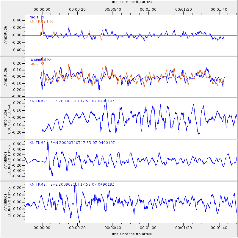
TKM2 KN.TKM2 - Earthquake Result Viewer
*The percent match for this event was below the threshold and hence no stack was calculated.
| Earthquake location: |
Near North Coast Of Irian Jaya |
| Earthquake latitude/longitude: |
-1.9/139.1 |
| Earthquake time(UTC): |
2009/03/10 (069) 17:42:14 GMT |
| Earthquake Depth: |
18 km |
| Earthquake Magnitude: |
5.5 MB, 5.2 MS, 5.5 MW, 5.4 MW |
| Earthquake Catalog/Contributor: |
WHDF/NEIC |
|
| Network: |
KN Kyrgyz Seismic Telemetry Network |
| Station: |
TKM2 KN.TKM2 |
| Lat/Lon: |
42.92 N/75.60 E |
| Elevation: |
2020 m |
|
| Distance: |
72.2 deg |
| Az: |
316.332 deg |
| Baz: |
110.037 deg |
| Ray Param: |
$rayparam |
*The percent match for this event was below the threshold and hence was not used in the summary stack. |
|
| Radial Match: |
50.765194 % |
| Radial Bump: |
400 |
| Transverse Match: |
61.10403 % |
| Transverse Bump: |
400 |
| SOD ConfigId: |
2658 |
| Insert Time: |
2010-03-08 21:14:21.475 +0000 |
| GWidth: |
2.5 |
| Max Bumps: |
400 |
| Tol: |
0.001 |
|
Signal To Noise
| Channel | StoN | STA | LTA |
| KN:TKM2: :BHN:20090310T17:53:07.049019Z | 5.357684 | 2.6520553E-7 | 4.9500034E-8 |
| KN:TKM2: :BHE:20090310T17:53:07.049019Z | 0.80245864 | 7.295578E-8 | 9.0915314E-8 |
| KN:TKM2: :BHZ:20090310T17:53:07.049019Z | 0.964591 | 7.531491E-8 | 7.807963E-8 |
| Arrivals |
| Ps | |
| PpPs | |
| PsPs/PpSs | |


