You are here: Home > Network List > KN - Kyrgyz Seismic Telemetry Network Stations List
> Station TKM2 KN.TKM2 > Earthquake Result Viewer
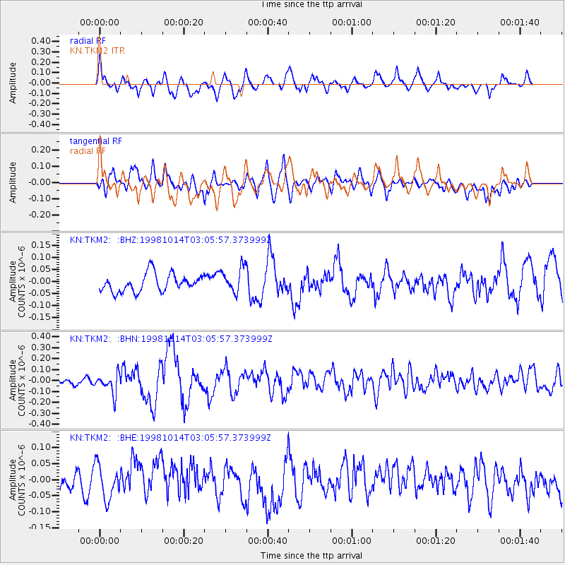
TKM2 KN.TKM2 - Earthquake Result Viewer
*The percent match for this event was below the threshold and hence no stack was calculated.
| Earthquake location: |
New Britain Region, P.N.G. |
| Earthquake latitude/longitude: |
-5.9/151.0 |
| Earthquake time(UTC): |
1998/10/14 (287) 02:54:04 GMT |
| Earthquake Depth: |
33 km |
| Earthquake Magnitude: |
5.5 MB, 5.7 MS, 6.0 UNKNOWN, 5.8 MW |
| Earthquake Catalog/Contributor: |
WHDF/NEIC |
|
| Network: |
KN Kyrgyz Seismic Telemetry Network |
| Station: |
TKM2 KN.TKM2 |
| Lat/Lon: |
42.92 N/75.60 E |
| Elevation: |
2020 m |
|
| Distance: |
83.4 deg |
| Az: |
314.302 deg |
| Baz: |
104.271 deg |
| Ray Param: |
$rayparam |
*The percent match for this event was below the threshold and hence was not used in the summary stack. |
|
| Radial Match: |
64.27947 % |
| Radial Bump: |
400 |
| Transverse Match: |
53.75612 % |
| Transverse Bump: |
400 |
| SOD ConfigId: |
4480 |
| Insert Time: |
2010-03-08 21:14:30.296 +0000 |
| GWidth: |
2.5 |
| Max Bumps: |
400 |
| Tol: |
0.001 |
|
Signal To Noise
| Channel | StoN | STA | LTA |
| KN:TKM2: :BHN:19981014T03:05:57.373999Z | 3.5261707 | 9.358401E-8 | 2.653984E-8 |
| KN:TKM2: :BHE:19981014T03:05:57.373999Z | 1.0820092 | 5.622011E-8 | 5.1958995E-8 |
| KN:TKM2: :BHZ:19981014T03:05:57.373999Z | 1.4740856 | 5.356452E-8 | 3.6337457E-8 |
| Arrivals |
| Ps | |
| PpPs | |
| PsPs/PpSs | |


