You are here: Home > Network List > GS - US Geological Survey Networks Stations List
> Station KAN08 Pence Farm, Harper, KS, USA > Earthquake Result Viewer
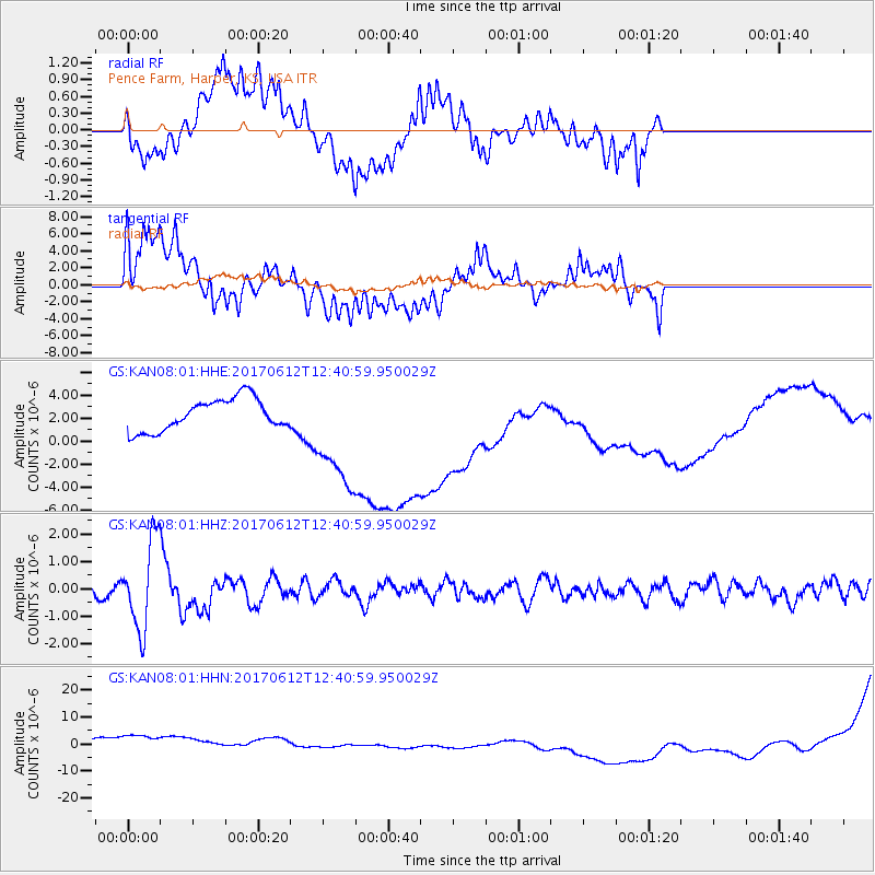
KAN08 Pence Farm, Harper, KS, USA - Earthquake Result Viewer
*The percent match for this event was below the threshold and hence no stack was calculated.
| Earthquake location: |
Aegean Sea |
| Earthquake latitude/longitude: |
38.9/26.4 |
| Earthquake time(UTC): |
2017/06/12 (163) 12:28:38 GMT |
| Earthquake Depth: |
10 km |
| Earthquake Magnitude: |
6.3 Mww |
| Earthquake Catalog/Contributor: |
NEIC PDE/us |
|
| Network: |
GS US Geological Survey Networks |
| Station: |
KAN08 Pence Farm, Harper, KS, USA |
| Lat/Lon: |
37.23 N/97.97 W |
| Elevation: |
375 m |
|
| Distance: |
88.5 deg |
| Az: |
318.75 deg |
| Baz: |
40.111 deg |
| Ray Param: |
$rayparam |
*The percent match for this event was below the threshold and hence was not used in the summary stack. |
|
| Radial Match: |
20.574024 % |
| Radial Bump: |
400 |
| Transverse Match: |
19.116604 % |
| Transverse Bump: |
400 |
| SOD ConfigId: |
2140511 |
| Insert Time: |
2017-06-26 04:22:13.570 +0000 |
| GWidth: |
2.5 |
| Max Bumps: |
400 |
| Tol: |
0.001 |
|
Signal To Noise
| Channel | StoN | STA | LTA |
| GS:KAN08:01:HHZ:20170612T12:40:59.950029Z | 5.70877 | 1.5938105E-6 | 2.791863E-7 |
| GS:KAN08:01:HHN:20170612T12:40:59.950029Z | 1.9474449 | 6.4379688E-6 | 3.305854E-6 |
| GS:KAN08:01:HHE:20170612T12:40:59.950029Z | 3.5238073 | 4.897418E-6 | 1.3898086E-6 |
| Arrivals |
| Ps | |
| PpPs | |
| PsPs/PpSs | |


