You are here: Home > Network List > KN - Kyrgyz Seismic Telemetry Network Stations List
> Station TKM2 KN.TKM2 > Earthquake Result Viewer
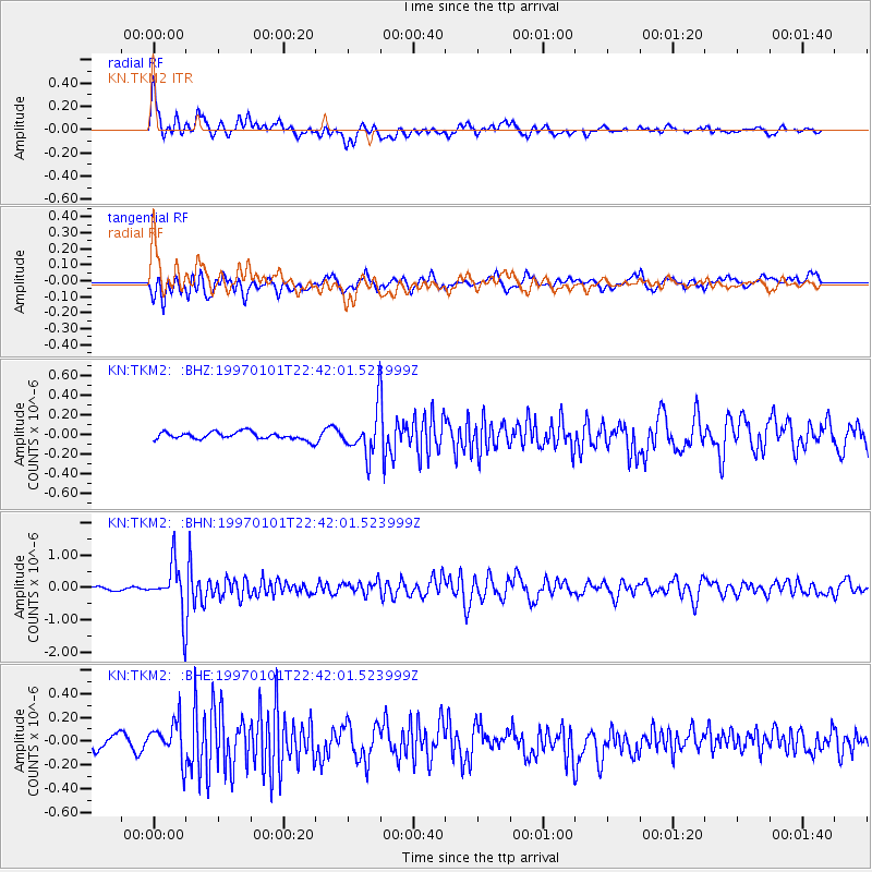
TKM2 KN.TKM2 - Earthquake Result Viewer
*The percent match for this event was below the threshold and hence no stack was calculated.
| Earthquake location: |
Minahassa Peninsula, Sulawesi |
| Earthquake latitude/longitude: |
-0.1/123.8 |
| Earthquake time(UTC): |
1997/01/01 (001) 22:32:32 GMT |
| Earthquake Depth: |
115 km |
| Earthquake Magnitude: |
5.9 MB, 5.8 UNKNOWN, 5.7 MW |
| Earthquake Catalog/Contributor: |
WHDF/NEIC |
|
| Network: |
KN Kyrgyz Seismic Telemetry Network |
| Station: |
TKM2 KN.TKM2 |
| Lat/Lon: |
42.92 N/75.60 E |
| Elevation: |
2020 m |
|
| Distance: |
60.8 deg |
| Az: |
321.128 deg |
| Baz: |
121.311 deg |
| Ray Param: |
$rayparam |
*The percent match for this event was below the threshold and hence was not used in the summary stack. |
|
| Radial Match: |
77.311646 % |
| Radial Bump: |
400 |
| Transverse Match: |
70.46358 % |
| Transverse Bump: |
400 |
| SOD ConfigId: |
4480 |
| Insert Time: |
2010-03-08 21:14:32.038 +0000 |
| GWidth: |
2.5 |
| Max Bumps: |
400 |
| Tol: |
0.001 |
|
Signal To Noise
| Channel | StoN | STA | LTA |
| KN:TKM2: :BHN:19970101T22:42:01.523999Z | 14.048722 | 7.488876E-7 | 5.3306454E-8 |
| KN:TKM2: :BHE:19970101T22:42:01.523999Z | 2.5886724 | 1.6743768E-7 | 6.4680904E-8 |
| KN:TKM2: :BHZ:19970101T22:42:01.523999Z | 5.768915 | 2.1740028E-7 | 3.7684778E-8 |
| Arrivals |
| Ps | |
| PpPs | |
| PsPs/PpSs | |


