You are here: Home > Network List > KN - Kyrgyz Seismic Telemetry Network Stations List
> Station TKM2 KN.TKM2 > Earthquake Result Viewer
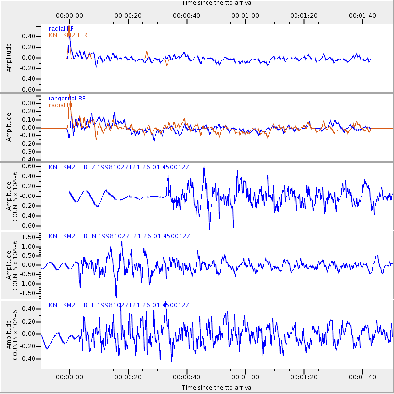
TKM2 KN.TKM2 - Earthquake Result Viewer
*The percent match for this event was below the threshold and hence no stack was calculated.
| Earthquake location: |
Halmahera, Indonesia |
| Earthquake latitude/longitude: |
2.9/128.6 |
| Earthquake time(UTC): |
1998/10/27 (300) 21:16:21 GMT |
| Earthquake Depth: |
61 km |
| Earthquake Magnitude: |
5.9 MB, 5.9 UNKNOWN, 5.9 MW |
| Earthquake Catalog/Contributor: |
WHDF/NEIC |
|
| Network: |
KN Kyrgyz Seismic Telemetry Network |
| Station: |
TKM2 KN.TKM2 |
| Lat/Lon: |
42.92 N/75.60 E |
| Elevation: |
2020 m |
|
| Distance: |
61.6 deg |
| Az: |
318.154 deg |
| Baz: |
114.902 deg |
| Ray Param: |
$rayparam |
*The percent match for this event was below the threshold and hence was not used in the summary stack. |
|
| Radial Match: |
65.89189 % |
| Radial Bump: |
400 |
| Transverse Match: |
61.369896 % |
| Transverse Bump: |
400 |
| SOD ConfigId: |
4480 |
| Insert Time: |
2010-03-08 21:14:34.558 +0000 |
| GWidth: |
2.5 |
| Max Bumps: |
400 |
| Tol: |
0.001 |
|
Signal To Noise
| Channel | StoN | STA | LTA |
| KN:TKM2: :BHN:19981027T21:26:01.450012Z | 2.9632063 | 3.17186E-7 | 1.0704148E-7 |
| KN:TKM2: :BHE:19981027T21:26:01.450012Z | 1.0073893 | 1.1872738E-7 | 1.178565E-7 |
| KN:TKM2: :BHZ:19981027T21:26:01.450012Z | 1.6833823 | 1.3385358E-7 | 7.951467E-8 |
| Arrivals |
| Ps | |
| PpPs | |
| PsPs/PpSs | |


