You are here: Home > Network List > GS - US Geological Survey Networks Stations List
> Station OK033 Mehan, Oklahoma, USA > Earthquake Result Viewer
OK033 Mehan, Oklahoma, USA - Earthquake Result Viewer
| Earthquake location: |
Aegean Sea |
| Earthquake latitude/longitude: |
38.9/26.4 |
| Earthquake time(UTC): |
2017/06/12 (163) 12:28:38 GMT |
| Earthquake Depth: |
10 km |
| Earthquake Magnitude: |
6.3 Mww |
| Earthquake Catalog/Contributor: |
NEIC PDE/us |
|
| Network: |
GS US Geological Survey Networks |
| Station: |
OK033 Mehan, Oklahoma, USA |
| Lat/Lon: |
36.04 N/96.94 W |
| Elevation: |
258 m |
|
| Distance: |
88.9 deg |
| Az: |
317.353 deg |
| Baz: |
40.693 deg |
| Ray Param: |
0.042257823 |
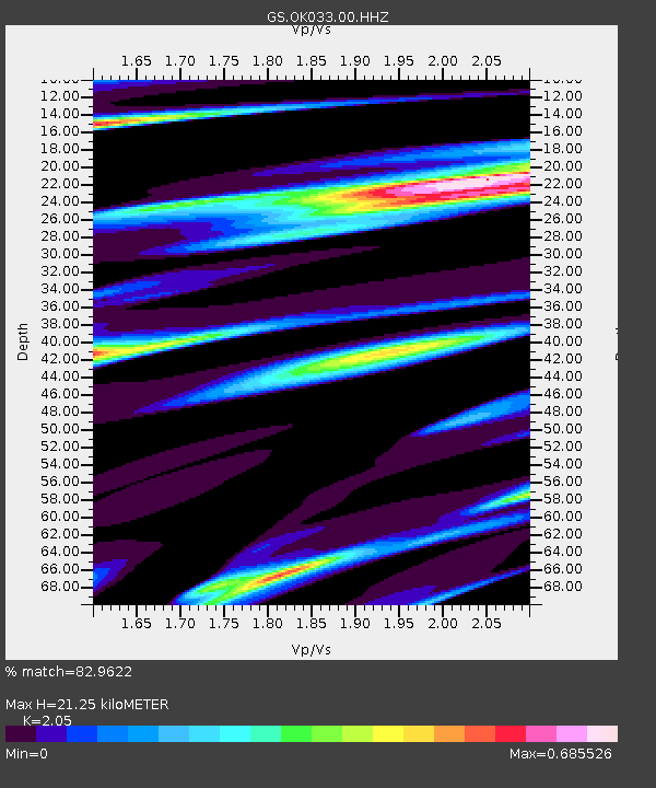
| Estimated Moho Depth: |
21.25 km |
| Estimated Crust Vp/Vs: |
2.05 |
| Assumed Crust Vp: |
6.483 km/s |
| Estimated Crust Vs: |
3.162 km/s |
| Estimated Crust Poisson's Ratio: |
0.34 |
|
| Radial Match: |
82.9622 % |
| Radial Bump: |
323 |
| Transverse Match: |
54.682896 % |
| Transverse Bump: |
400 |
| SOD ConfigId: |
2140511 |
| Insert Time: |
2017-06-26 04:22:25.535 +0000 |
| GWidth: |
2.5 |
| Max Bumps: |
400 |
| Tol: |
0.001 |
|

Signal To Noise
| Channel | StoN | STA | LTA |
| GS:OK033:00:HHZ:20170612T12:41:01.639971Z | 9.67888 | 2.0576488E-6 | 2.1259163E-7 |
| GS:OK033:00:HH1:20170612T12:41:01.639971Z | 3.4758942 | 7.161734E-7 | 2.0604004E-7 |
| GS:OK033:00:HH2:20170612T12:41:01.639971Z | 2.048307 | 3.1061356E-7 | 1.5164406E-7 |
| Arrivals |
| Ps | 3.5 SECOND |
| PpPs | 9.8 SECOND |
| PsPs/PpSs | 13 SECOND |


