You are here: Home > Network List > GT - Global Telemetered Seismograph Network (USAF/USGS) Stations List
> Station BOSA Boshof, South Africa > Earthquake Result Viewer
BOSA Boshof, South Africa - Earthquake Result Viewer
| Earthquake location: |
Aegean Sea |
| Earthquake latitude/longitude: |
38.9/26.4 |
| Earthquake time(UTC): |
2017/06/12 (163) 12:28:38 GMT |
| Earthquake Depth: |
10 km |
| Earthquake Magnitude: |
6.3 Mww |
| Earthquake Catalog/Contributor: |
NEIC PDE/us |
|
| Network: |
GT Global Telemetered Seismograph Network (USAF/USGS) |
| Station: |
BOSA Boshof, South Africa |
| Lat/Lon: |
28.61 S/25.26 E |
| Elevation: |
1280 m |
|
| Distance: |
67.2 deg |
| Az: |
181.057 deg |
| Baz: |
0.937 deg |
| Ray Param: |
0.05710786 |
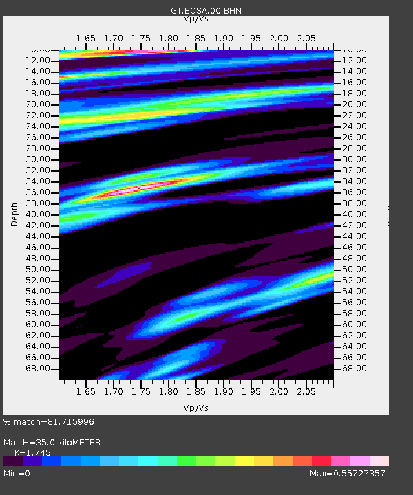
| Estimated Moho Depth: |
35.0 km |
| Estimated Crust Vp/Vs: |
1.75 |
| Assumed Crust Vp: |
6.459 km/s |
| Estimated Crust Vs: |
3.702 km/s |
| Estimated Crust Poisson's Ratio: |
0.26 |
|
| Radial Match: |
81.715996 % |
| Radial Bump: |
400 |
| Transverse Match: |
54.225674 % |
| Transverse Bump: |
349 |
| SOD ConfigId: |
2140511 |
| Insert Time: |
2017-06-26 04:22:37.649 +0000 |
| GWidth: |
2.5 |
| Max Bumps: |
400 |
| Tol: |
0.001 |
|
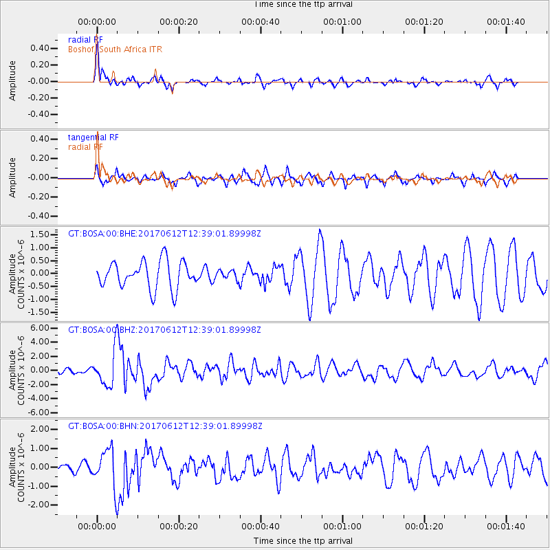
Signal To Noise
| Channel | StoN | STA | LTA |
| GT:BOSA:00:BHZ:20170612T12:39:01.89998Z | 6.404608 | 2.5200527E-6 | 3.9347495E-7 |
| GT:BOSA:00:BHN:20170612T12:39:01.89998Z | 2.9465919 | 1.0327283E-6 | 3.5048228E-7 |
| GT:BOSA:00:BHE:20170612T12:39:01.89998Z | 0.33528855 | 1.7564524E-7 | 5.238629E-7 |
| Arrivals |
| Ps | 4.2 SECOND |
| PpPs | 14 SECOND |
| PsPs/PpSs | 18 SECOND |


