You are here: Home > Network List > KN - Kyrgyz Seismic Telemetry Network Stations List
> Station TKM2 KN.TKM2 > Earthquake Result Viewer
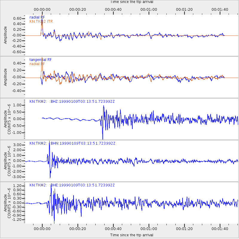
TKM2 KN.TKM2 - Earthquake Result Viewer
*The percent match for this event was below the threshold and hence no stack was calculated.
| Earthquake location: |
Kuril Islands |
| Earthquake latitude/longitude: |
44.4/147.3 |
| Earthquake time(UTC): |
1999/01/09 (009) 03:05:37 GMT |
| Earthquake Depth: |
119 km |
| Earthquake Magnitude: |
5.8 MB, 5.8 MW, 5.6 MW |
| Earthquake Catalog/Contributor: |
WHDF/NEIC |
|
| Network: |
KN Kyrgyz Seismic Telemetry Network |
| Station: |
TKM2 KN.TKM2 |
| Lat/Lon: |
42.92 N/75.60 E |
| Elevation: |
2020 m |
|
| Distance: |
50.3 deg |
| Az: |
295.038 deg |
| Baz: |
62.163 deg |
| Ray Param: |
$rayparam |
*The percent match for this event was below the threshold and hence was not used in the summary stack. |
|
| Radial Match: |
78.63002 % |
| Radial Bump: |
400 |
| Transverse Match: |
76.65398 % |
| Transverse Bump: |
400 |
| SOD ConfigId: |
4480 |
| Insert Time: |
2010-03-08 21:14:56.028 +0000 |
| GWidth: |
2.5 |
| Max Bumps: |
400 |
| Tol: |
0.001 |
|
Signal To Noise
| Channel | StoN | STA | LTA |
| KN:TKM2: :BHN:19990109T03:13:51.723992Z | 22.735125 | 1.1196455E-6 | 4.9247387E-8 |
| KN:TKM2: :BHE:19990109T03:13:51.723992Z | 6.123988 | 2.4349646E-7 | 3.976109E-8 |
| KN:TKM2: :BHZ:19990109T03:13:51.723992Z | 8.558972 | 4.4506172E-7 | 5.1999432E-8 |
| Arrivals |
| Ps | |
| PpPs | |
| PsPs/PpSs | |


