You are here: Home > Network List > KN - Kyrgyz Seismic Telemetry Network Stations List
> Station TKM2 KN.TKM2 > Earthquake Result Viewer
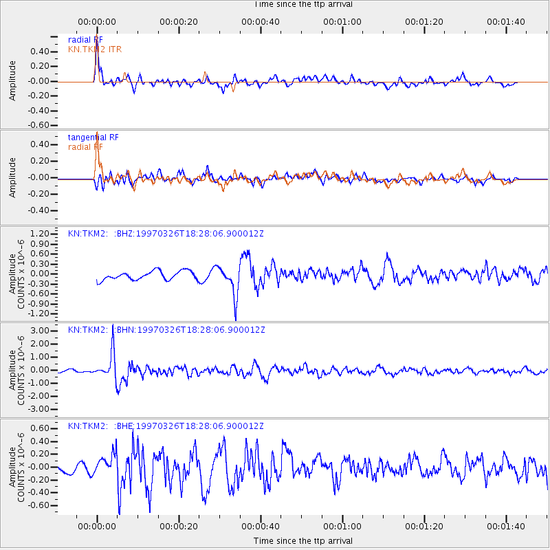
TKM2 KN.TKM2 - Earthquake Result Viewer
*The percent match for this event was below the threshold and hence no stack was calculated.
| Earthquake location: |
Halmahera, Indonesia |
| Earthquake latitude/longitude: |
2.8/128.2 |
| Earthquake time(UTC): |
1997/03/26 (085) 18:18:34 GMT |
| Earthquake Depth: |
127 km |
| Earthquake Magnitude: |
5.7 MB, 5.9 UNKNOWN, 5.8 MW |
| Earthquake Catalog/Contributor: |
WHDF/NEIC |
|
| Network: |
KN Kyrgyz Seismic Telemetry Network |
| Station: |
TKM2 KN.TKM2 |
| Lat/Lon: |
42.92 N/75.60 E |
| Elevation: |
2020 m |
|
| Distance: |
61.4 deg |
| Az: |
318.333 deg |
| Baz: |
115.318 deg |
| Ray Param: |
$rayparam |
*The percent match for this event was below the threshold and hence was not used in the summary stack. |
|
| Radial Match: |
64.82956 % |
| Radial Bump: |
400 |
| Transverse Match: |
58.671463 % |
| Transverse Bump: |
400 |
| SOD ConfigId: |
4480 |
| Insert Time: |
2010-03-08 21:14:58.936 +0000 |
| GWidth: |
2.5 |
| Max Bumps: |
400 |
| Tol: |
0.001 |
|
Signal To Noise
| Channel | StoN | STA | LTA |
| KN:TKM2: :BHN:19970326T18:28:06.900012Z | 12.177267 | 1.0248043E-6 | 8.4157165E-8 |
| KN:TKM2: :BHE:19970326T18:28:06.900012Z | 1.2311729 | 1.3928644E-7 | 1.13133126E-7 |
| KN:TKM2: :BHZ:19970326T18:28:06.900012Z | 3.3827345 | 4.437308E-7 | 1.3117518E-7 |
| Arrivals |
| Ps | |
| PpPs | |
| PsPs/PpSs | |


