You are here: Home > Network List > KN - Kyrgyz Seismic Telemetry Network Stations List
> Station TKM2 KN.TKM2 > Earthquake Result Viewer
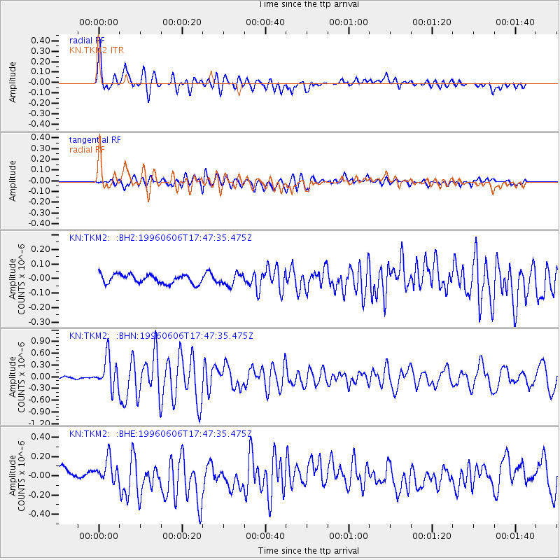
TKM2 KN.TKM2 - Earthquake Result Viewer
*The percent match for this event was below the threshold and hence no stack was calculated.
| Earthquake location: |
Mid-Indian Ridge |
| Earthquake latitude/longitude: |
-41.3/80.7 |
| Earthquake time(UTC): |
1996/06/06 (158) 17:35:38 GMT |
| Earthquake Depth: |
20 km |
| Earthquake Magnitude: |
5.5 MB, 5.9 MS, 6.3 UNKNOWN, 6.2 MW |
| Earthquake Catalog/Contributor: |
WHDF/NEIC |
|
| Network: |
KN Kyrgyz Seismic Telemetry Network |
| Station: |
TKM2 KN.TKM2 |
| Lat/Lon: |
42.92 N/75.60 E |
| Elevation: |
2020 m |
|
| Distance: |
84.0 deg |
| Az: |
356.258 deg |
| Baz: |
176.163 deg |
| Ray Param: |
$rayparam |
*The percent match for this event was below the threshold and hence was not used in the summary stack. |
|
| Radial Match: |
79.49981 % |
| Radial Bump: |
400 |
| Transverse Match: |
68.56157 % |
| Transverse Bump: |
400 |
| SOD ConfigId: |
4480 |
| Insert Time: |
2010-03-08 21:15:00.610 +0000 |
| GWidth: |
2.5 |
| Max Bumps: |
400 |
| Tol: |
0.001 |
|
Signal To Noise
| Channel | StoN | STA | LTA |
| KN:TKM2: :BHN:19960606T17:47:35.475Z | 11.398164 | 4.0988127E-7 | 3.5960287E-8 |
| KN:TKM2: :BHE:19960606T17:47:35.475Z | 2.540837 | 1.204255E-7 | 4.7395996E-8 |
| KN:TKM2: :BHZ:19960606T17:47:35.475Z | 1.3133982 | 3.993167E-8 | 3.040332E-8 |
| Arrivals |
| Ps | |
| PpPs | |
| PsPs/PpSs | |


