You are here: Home > Network List > KN - Kyrgyz Seismic Telemetry Network Stations List
> Station TKM2 KN.TKM2 > Earthquake Result Viewer
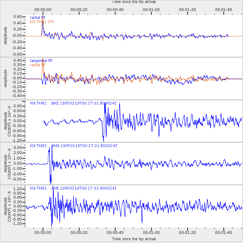
TKM2 KN.TKM2 - Earthquake Result Viewer
*The percent match for this event was below the threshold and hence no stack was calculated.
| Earthquake location: |
Mindanao, Philippines |
| Earthquake latitude/longitude: |
5.2/126.2 |
| Earthquake time(UTC): |
1995/02/19 (050) 00:17:48 GMT |
| Earthquake Depth: |
104 km |
| Earthquake Magnitude: |
5.9 MB, 6.1 UNKNOWN, 6.1 MW |
| Earthquake Catalog/Contributor: |
WHDF/NEIC |
|
| Network: |
KN Kyrgyz Seismic Telemetry Network |
| Station: |
TKM2 KN.TKM2 |
| Lat/Lon: |
42.92 N/75.60 E |
| Elevation: |
2020 m |
|
| Distance: |
58.3 deg |
| Az: |
318.14 deg |
| Baz: |
115.211 deg |
| Ray Param: |
$rayparam |
*The percent match for this event was below the threshold and hence was not used in the summary stack. |
|
| Radial Match: |
79.855804 % |
| Radial Bump: |
400 |
| Transverse Match: |
65.68881 % |
| Transverse Bump: |
400 |
| SOD ConfigId: |
4480 |
| Insert Time: |
2010-03-08 21:15:07.680 +0000 |
| GWidth: |
2.5 |
| Max Bumps: |
400 |
| Tol: |
0.001 |
|
Signal To Noise
| Channel | StoN | STA | LTA |
| KN:TKM2: :BHN:19950219T00:27:01.800024Z | 14.344575 | 1.5048262E-6 | 1.049056E-7 |
| KN:TKM2: :BHE:19950219T00:27:01.800024Z | 4.6201396 | 3.1082266E-7 | 6.72756E-8 |
| KN:TKM2: :BHZ:19950219T00:27:01.800024Z | 6.502112 | 5.016146E-7 | 7.71464E-8 |
| Arrivals |
| Ps | |
| PpPs | |
| PsPs/PpSs | |


