You are here: Home > Network List > KN - Kyrgyz Seismic Telemetry Network Stations List
> Station TKM2 KN.TKM2 > Earthquake Result Viewer
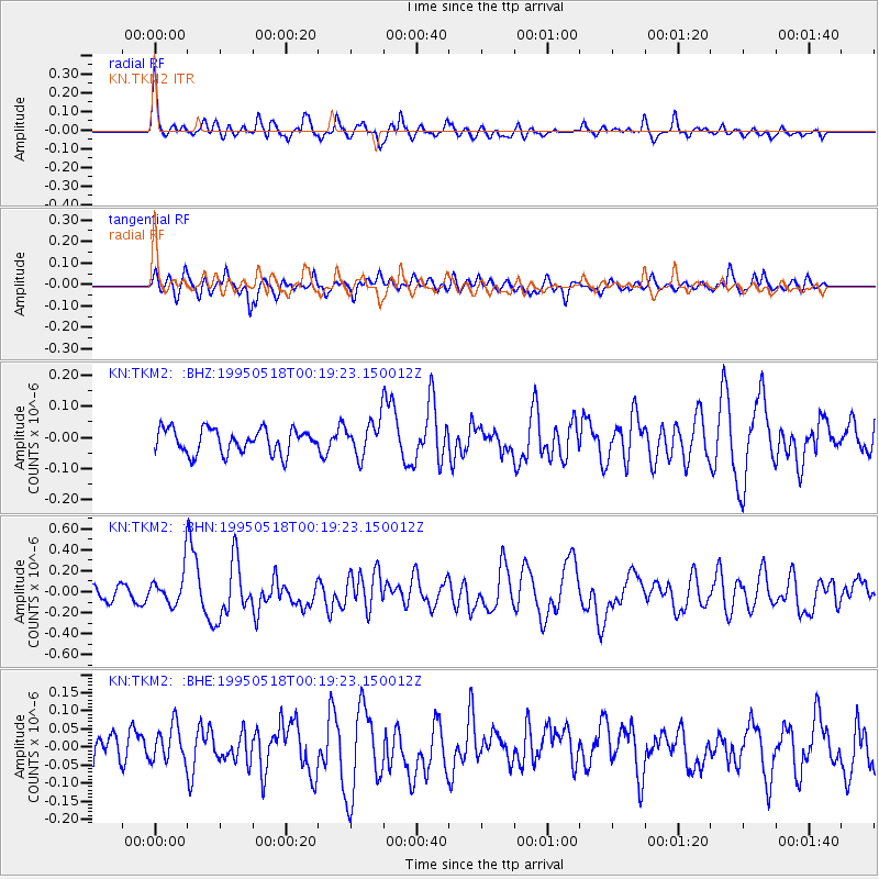
TKM2 KN.TKM2 - Earthquake Result Viewer
*The percent match for this event was below the threshold and hence no stack was calculated.
| Earthquake location: |
Central Mid-Atlantic Ridge |
| Earthquake latitude/longitude: |
-0.9/-22.0 |
| Earthquake time(UTC): |
1995/05/18 (138) 00:06:26 GMT |
| Earthquake Depth: |
10 km |
| Earthquake Magnitude: |
6.2 MB, 6.1 MS, 6.8 UNKNOWN, 6.7 MW |
| Earthquake Catalog/Contributor: |
WHDF/NEIC |
|
| Network: |
KN Kyrgyz Seismic Telemetry Network |
| Station: |
TKM2 KN.TKM2 |
| Lat/Lon: |
42.92 N/75.60 E |
| Elevation: |
2020 m |
|
| Distance: |
96.2 deg |
| Az: |
47.091 deg |
| Baz: |
274.466 deg |
| Ray Param: |
$rayparam |
*The percent match for this event was below the threshold and hence was not used in the summary stack. |
|
| Radial Match: |
77.15725 % |
| Radial Bump: |
400 |
| Transverse Match: |
58.673325 % |
| Transverse Bump: |
400 |
| SOD ConfigId: |
4480 |
| Insert Time: |
2010-03-08 21:15:28.515 +0000 |
| GWidth: |
2.5 |
| Max Bumps: |
400 |
| Tol: |
0.001 |
|
Signal To Noise
| Channel | StoN | STA | LTA |
| KN:TKM2: :BHN:19950518T00:19:23.150012Z | 2.7791026 | 1.6994166E-7 | 6.1149834E-8 |
| KN:TKM2: :BHE:19950518T00:19:23.150012Z | 1.155321 | 4.9104532E-8 | 4.2502936E-8 |
| KN:TKM2: :BHZ:19950518T00:19:23.150012Z | 1.4539952 | 5.66874E-8 | 3.8987334E-8 |
| Arrivals |
| Ps | |
| PpPs | |
| PsPs/PpSs | |


