You are here: Home > Network List > AV - Alaska Volcano Observatory Stations List
> Station GSCK Cape Kiugilak, Great Sitkin Volcano, Alaska > Earthquake Result Viewer
GSCK Cape Kiugilak, Great Sitkin Volcano, Alaska - Earthquake Result Viewer
| Earthquake location: |
Ryukyu Islands, Japan |
| Earthquake latitude/longitude: |
28.9/128.3 |
| Earthquake time(UTC): |
2020/06/13 (165) 15:51:23 GMT |
| Earthquake Depth: |
160 km |
| Earthquake Magnitude: |
6.6 Mww |
| Earthquake Catalog/Contributor: |
NEIC PDE/us |
|
| Network: |
AV Alaska Volcano Observatory |
| Station: |
GSCK Cape Kiugilak, Great Sitkin Volcano, Alaska |
| Lat/Lon: |
52.01 N/176.16 W |
| Elevation: |
384 m |
|
| Distance: |
46.8 deg |
| Az: |
44.388 deg |
| Baz: |
262.748 deg |
| Ray Param: |
0.069844924 |
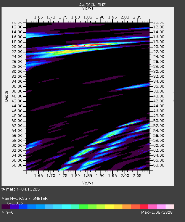
| Estimated Moho Depth: |
19.25 km |
| Estimated Crust Vp/Vs: |
1.84 |
| Assumed Crust Vp: |
3.912 km/s |
| Estimated Crust Vs: |
2.132 km/s |
| Estimated Crust Poisson's Ratio: |
0.29 |
|
| Radial Match: |
84.13205 % |
| Radial Bump: |
400 |
| Transverse Match: |
78.550285 % |
| Transverse Bump: |
400 |
| SOD ConfigId: |
21709731 |
| Insert Time: |
2020-06-27 15:57:15.382 +0000 |
| GWidth: |
2.5 |
| Max Bumps: |
400 |
| Tol: |
0.001 |
|

Signal To Noise
| Channel | StoN | STA | LTA |
| AV:GSCK: :BHZ:20200613T15:59:06.279987Z | 10.737774 | 1.2057718E-6 | 1.1229254E-7 |
| AV:GSCK: :BHN:20200613T15:59:06.279987Z | 2.5116367 | 5.2217484E-7 | 2.079022E-7 |
| AV:GSCK: :BHE:20200613T15:59:06.279987Z | 2.6540937 | 7.5073154E-7 | 2.8285797E-7 |
| Arrivals |
| Ps | 4.2 SECOND |
| PpPs | 14 SECOND |
| PsPs/PpSs | 18 SECOND |


