You are here: Home > Network List > AV - Alaska Volcano Observatory Stations List
> Station GSIG Igitkin Island, Great Sitkin Volcano, Alaska > Earthquake Result Viewer
GSIG Igitkin Island, Great Sitkin Volcano, Alaska - Earthquake Result Viewer
| Earthquake location: |
Ryukyu Islands, Japan |
| Earthquake latitude/longitude: |
28.9/128.3 |
| Earthquake time(UTC): |
2020/06/13 (165) 15:51:23 GMT |
| Earthquake Depth: |
160 km |
| Earthquake Magnitude: |
6.6 Mww |
| Earthquake Catalog/Contributor: |
NEIC PDE/us |
|
| Network: |
AV Alaska Volcano Observatory |
| Station: |
GSIG Igitkin Island, Great Sitkin Volcano, Alaska |
| Lat/Lon: |
51.99 N/175.93 W |
| Elevation: |
407 m |
|
| Distance: |
46.9 deg |
| Az: |
44.448 deg |
| Baz: |
262.975 deg |
| Ray Param: |
0.06975893 |
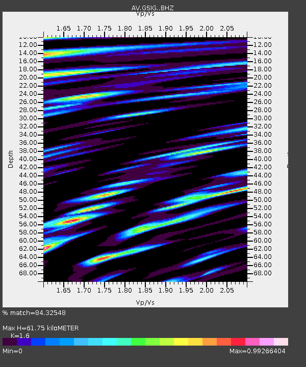
| Estimated Moho Depth: |
61.75 km |
| Estimated Crust Vp/Vs: |
1.60 |
| Assumed Crust Vp: |
3.943 km/s |
| Estimated Crust Vs: |
2.465 km/s |
| Estimated Crust Poisson's Ratio: |
0.18 |
|
| Radial Match: |
84.32548 % |
| Radial Bump: |
400 |
| Transverse Match: |
70.194664 % |
| Transverse Bump: |
400 |
| SOD ConfigId: |
21709731 |
| Insert Time: |
2020-06-27 15:57:15.521 +0000 |
| GWidth: |
2.5 |
| Max Bumps: |
400 |
| Tol: |
0.001 |
|

Signal To Noise
| Channel | StoN | STA | LTA |
| AV:GSIG: :BHZ:20200613T15:59:07.379993Z | 5.906851 | 9.058409E-7 | 1.5335429E-7 |
| AV:GSIG: :BHN:20200613T15:59:07.379993Z | 3.1218889 | 5.582751E-7 | 1.7882606E-7 |
| AV:GSIG: :BHE:20200613T15:59:07.379993Z | 6.59974 | 9.645797E-7 | 1.4615419E-7 |
| Arrivals |
| Ps | 9.6 SECOND |
| PpPs | 40 SECOND |
| PsPs/PpSs | 49 SECOND |


