You are here: Home > Network List > AV - Alaska Volcano Observatory Stations List
> Station KABU KABU - Katmai Volcanic Cluster, Alaska > Earthquake Result Viewer
KABU KABU - Katmai Volcanic Cluster, Alaska - Earthquake Result Viewer
| Earthquake location: |
Ryukyu Islands, Japan |
| Earthquake latitude/longitude: |
28.9/128.3 |
| Earthquake time(UTC): |
2020/06/13 (165) 15:51:23 GMT |
| Earthquake Depth: |
160 km |
| Earthquake Magnitude: |
6.6 Mww |
| Earthquake Catalog/Contributor: |
NEIC PDE/us |
|
| Network: |
AV Alaska Volcano Observatory |
| Station: |
KABU KABU - Katmai Volcanic Cluster, Alaska |
| Lat/Lon: |
58.27 N/155.28 W |
| Elevation: |
1065 m |
|
| Distance: |
58.9 deg |
| Az: |
36.889 deg |
| Baz: |
275.372 deg |
| Ray Param: |
0.062065758 |
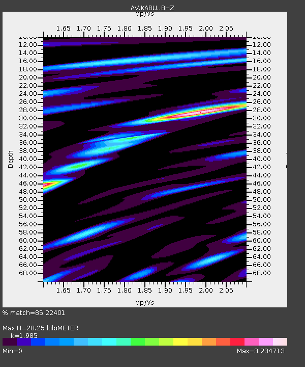
| Estimated Moho Depth: |
28.25 km |
| Estimated Crust Vp/Vs: |
1.99 |
| Assumed Crust Vp: |
6.438 km/s |
| Estimated Crust Vs: |
3.243 km/s |
| Estimated Crust Poisson's Ratio: |
0.33 |
|
| Radial Match: |
85.22401 % |
| Radial Bump: |
400 |
| Transverse Match: |
86.071365 % |
| Transverse Bump: |
400 |
| SOD ConfigId: |
21709731 |
| Insert Time: |
2020-06-27 15:57:27.405 +0000 |
| GWidth: |
2.5 |
| Max Bumps: |
400 |
| Tol: |
0.001 |
|

Signal To Noise
| Channel | StoN | STA | LTA |
| AV:KABU: :BHZ:20200613T16:00:34.568012Z | 11.896806 | 6.9000254E-7 | 5.7998975E-8 |
| AV:KABU: :BHN:20200613T16:00:34.568012Z | 5.3544044 | 3.3005023E-7 | 6.164088E-8 |
| AV:KABU: :BHE:20200613T16:00:34.568012Z | 18.987106 | 1.1863057E-6 | 6.247954E-8 |
| Arrivals |
| Ps | 4.5 SECOND |
| PpPs | 13 SECOND |
| PsPs/PpSs | 17 SECOND |


