You are here: Home > Network List > KN - Kyrgyz Seismic Telemetry Network Stations List
> Station TKM2 KN.TKM2 > Earthquake Result Viewer
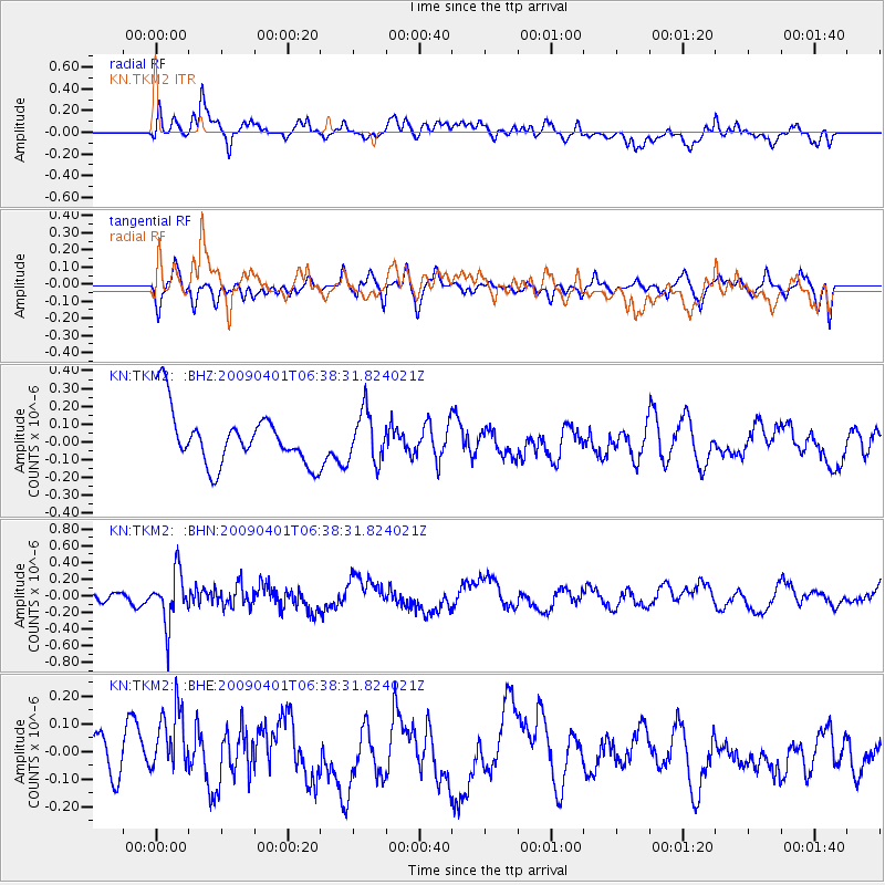
TKM2 KN.TKM2 - Earthquake Result Viewer
*The percent match for this event was below the threshold and hence no stack was calculated.
| Earthquake location: |
Southwest Of Sumatra, Indonesia |
| Earthquake latitude/longitude: |
-6.0/101.9 |
| Earthquake time(UTC): |
2009/04/01 (091) 06:29:40 GMT |
| Earthquake Depth: |
35 km |
| Earthquake Magnitude: |
5.6 MW, 5.2 MS, 5.3 MB |
| Earthquake Catalog/Contributor: |
WHDF/NEIC |
|
| Network: |
KN Kyrgyz Seismic Telemetry Network |
| Station: |
TKM2 KN.TKM2 |
| Lat/Lon: |
42.92 N/75.60 E |
| Elevation: |
2020 m |
|
| Distance: |
54.2 deg |
| Az: |
336.333 deg |
| Baz: |
147.074 deg |
| Ray Param: |
$rayparam |
*The percent match for this event was below the threshold and hence was not used in the summary stack. |
|
| Radial Match: |
52.849834 % |
| Radial Bump: |
400 |
| Transverse Match: |
38.59687 % |
| Transverse Bump: |
400 |
| SOD ConfigId: |
2658 |
| Insert Time: |
2010-03-08 21:15:43.671 +0000 |
| GWidth: |
2.5 |
| Max Bumps: |
400 |
| Tol: |
0.001 |
|
Signal To Noise
| Channel | StoN | STA | LTA |
| KN:TKM2: :BHN:20090401T06:38:31.824021Z | 3.778937 | 3.0312083E-7 | 8.0213255E-8 |
| KN:TKM2: :BHE:20090401T06:38:31.824021Z | 1.3619251 | 1.3248605E-7 | 9.727852E-8 |
| KN:TKM2: :BHZ:20090401T06:38:31.824021Z | 0.9297757 | 1.404662E-7 | 1.5107534E-7 |
| Arrivals |
| Ps | |
| PpPs | |
| PsPs/PpSs | |


