You are here: Home > Network List > KN - Kyrgyz Seismic Telemetry Network Stations List
> Station TKM2 KN.TKM2 > Earthquake Result Viewer
TKM2 KN.TKM2 - Earthquake Result Viewer
*The percent match for this event was below the threshold and hence no stack was calculated.
| Earthquake location: |
Tanimbar Islands Reg., Indonesia |
| Earthquake latitude/longitude: |
-8.0/130.2 |
| Earthquake time(UTC): |
2009/04/03 (093) 13:37:58 GMT |
| Earthquake Depth: |
35 km |
| Earthquake Magnitude: |
5.6 MW, 5.2 MS, 5.1 MB, 5.6 MW |
| Earthquake Catalog/Contributor: |
WHDF/NEIC |
|
| Network: |
KN Kyrgyz Seismic Telemetry Network |
| Station: |
TKM2 KN.TKM2 |
| Lat/Lon: |
42.92 N/75.60 E |
| Elevation: |
2020 m |
|
| Distance: |
70.9 deg |
| Az: |
320.662 deg |
| Baz: |
121.28 deg |
| Ray Param: |
$rayparam |
*The percent match for this event was below the threshold and hence was not used in the summary stack. |
|
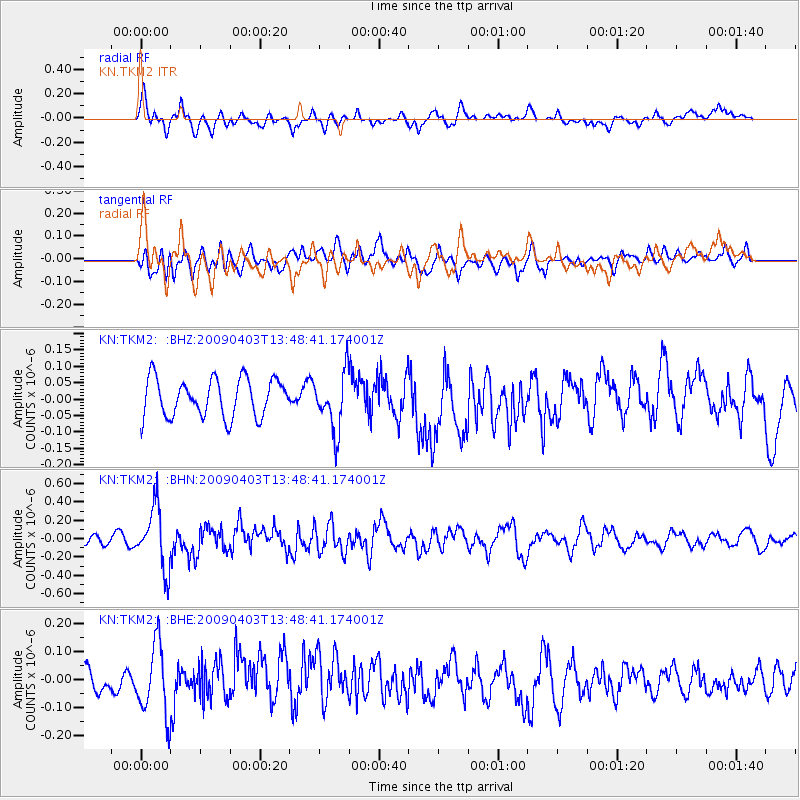
| Radial Match: |
63.884422 % |
| Radial Bump: |
400 |
| Transverse Match: |
42.21485 % |
| Transverse Bump: |
400 |
| SOD ConfigId: |
2658 |
| Insert Time: |
2010-03-08 21:15:45.291 +0000 |
| GWidth: |
2.5 |
| Max Bumps: |
400 |
| Tol: |
0.001 |
|
Signal To Noise
| Channel | StoN | STA | LTA |
| KN:TKM2: :BHN:20090403T13:48:41.174001Z | 3.9089015 | 3.352093E-7 | 8.5755374E-8 |
| KN:TKM2: :BHE:20090403T13:48:41.174001Z | 2.0382779 | 1.2584009E-7 | 6.173843E-8 |
| KN:TKM2: :BHZ:20090403T13:48:41.174001Z | 1.5176662 | 8.785535E-8 | 5.788845E-8 |
| Arrivals |
| Ps | |
| PpPs | |
| PsPs/PpSs | |


