You are here: Home > Network List > AV - Alaska Volcano Observatory Stations List
> Station P18K Big Mountain, AK, USA > Earthquake Result Viewer
P18K Big Mountain, AK, USA - Earthquake Result Viewer
| Earthquake location: |
Ryukyu Islands, Japan |
| Earthquake latitude/longitude: |
28.9/128.3 |
| Earthquake time(UTC): |
2020/06/13 (165) 15:51:23 GMT |
| Earthquake Depth: |
160 km |
| Earthquake Magnitude: |
6.6 Mww |
| Earthquake Catalog/Contributor: |
NEIC PDE/us |
|
| Network: |
AV Alaska Volcano Observatory |
| Station: |
P18K Big Mountain, AK, USA |
| Lat/Lon: |
59.39 N/155.23 W |
| Elevation: |
680 m |
|
| Distance: |
58.8 deg |
| Az: |
35.577 deg |
| Baz: |
274.737 deg |
| Ray Param: |
0.06211272 |
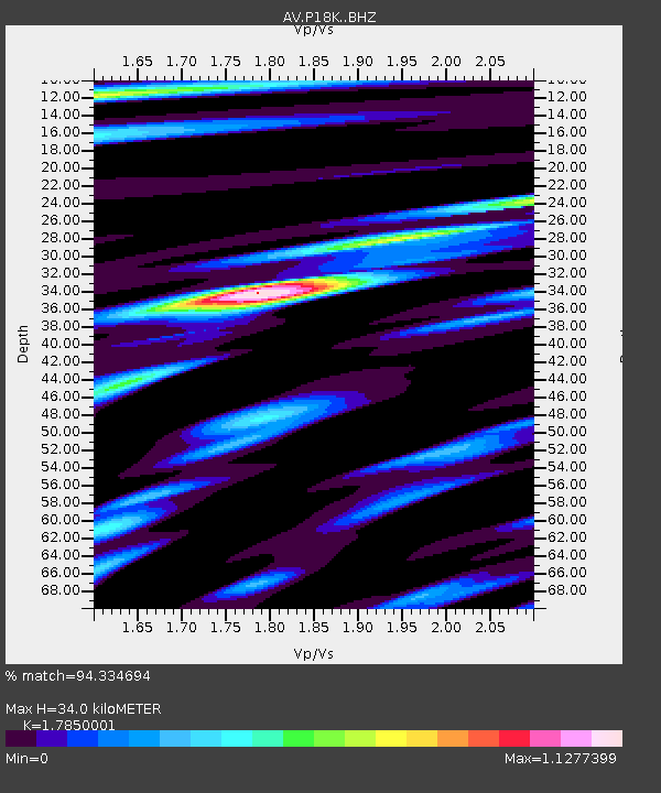
| Estimated Moho Depth: |
34.0 km |
| Estimated Crust Vp/Vs: |
1.79 |
| Assumed Crust Vp: |
6.438 km/s |
| Estimated Crust Vs: |
3.607 km/s |
| Estimated Crust Poisson's Ratio: |
0.27 |
|
| Radial Match: |
94.334694 % |
| Radial Bump: |
400 |
| Transverse Match: |
84.849815 % |
| Transverse Bump: |
400 |
| SOD ConfigId: |
21709731 |
| Insert Time: |
2020-06-27 15:58:34.582 +0000 |
| GWidth: |
2.5 |
| Max Bumps: |
400 |
| Tol: |
0.001 |
|

Signal To Noise
| Channel | StoN | STA | LTA |
| AV:P18K: :BHZ:20200613T16:00:34.07497Z | 16.940344 | 9.80046E-7 | 5.7852784E-8 |
| AV:P18K: :BHN:20200613T16:00:34.07497Z | 3.510888 | 1.686067E-7 | 4.8023946E-8 |
| AV:P18K: :BHE:20200613T16:00:34.07497Z | 5.7139997 | 3.6799713E-7 | 6.440272E-8 |
| Arrivals |
| Ps | 4.3 SECOND |
| PpPs | 14 SECOND |
| PsPs/PpSs | 18 SECOND |


