You are here: Home > Network List > KN - Kyrgyz Seismic Telemetry Network Stations List
> Station TKM2 KN.TKM2 > Earthquake Result Viewer
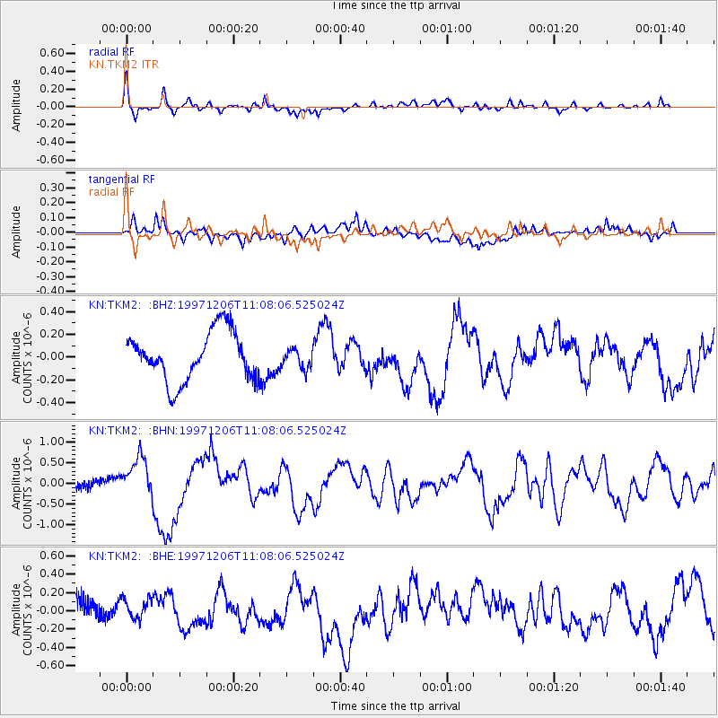
TKM2 KN.TKM2 - Earthquake Result Viewer
*The percent match for this event was below the threshold and hence no stack was calculated.
| Earthquake location: |
Off East Coast Of Kamchatka |
| Earthquake latitude/longitude: |
54.0/161.9 |
| Earthquake time(UTC): |
1997/12/06 (340) 10:59:10 GMT |
| Earthquake Depth: |
33 km |
| Earthquake Magnitude: |
5.7 MB, 5.8 MS, 6.1 UNKNOWN, 6.1 MW |
| Earthquake Catalog/Contributor: |
WHDF/NEIC |
|
| Network: |
KN Kyrgyz Seismic Telemetry Network |
| Station: |
TKM2 KN.TKM2 |
| Lat/Lon: |
42.92 N/75.60 E |
| Elevation: |
2020 m |
|
| Distance: |
54.9 deg |
| Az: |
296.327 deg |
| Baz: |
46.121 deg |
| Ray Param: |
$rayparam |
*The percent match for this event was below the threshold and hence was not used in the summary stack. |
|
| Radial Match: |
69.744514 % |
| Radial Bump: |
400 |
| Transverse Match: |
59.236267 % |
| Transverse Bump: |
400 |
| SOD ConfigId: |
4480 |
| Insert Time: |
2010-03-08 21:15:55.639 +0000 |
| GWidth: |
2.5 |
| Max Bumps: |
400 |
| Tol: |
0.001 |
|
Signal To Noise
| Channel | StoN | STA | LTA |
| KN:TKM2: :BHN:19971206T11:08:06.525024Z | 6.003586 | 4.9352377E-7 | 8.220483E-8 |
| KN:TKM2: :BHE:19971206T11:08:06.525024Z | 0.56916636 | 1.09604926E-7 | 1.92571E-7 |
| KN:TKM2: :BHZ:19971206T11:08:06.525024Z | 0.3967718 | 8.443027E-8 | 2.1279303E-7 |
| Arrivals |
| Ps | |
| PpPs | |
| PsPs/PpSs | |


