You are here: Home > Network List > CC - Cascade Chain Volcano Monitoring Stations List
> Station STD Studebaker Ridge, Mount St. Helens > Earthquake Result Viewer
STD Studebaker Ridge, Mount St. Helens - Earthquake Result Viewer
| Earthquake location: |
Ryukyu Islands, Japan |
| Earthquake latitude/longitude: |
28.9/128.3 |
| Earthquake time(UTC): |
2020/06/13 (165) 15:51:23 GMT |
| Earthquake Depth: |
160 km |
| Earthquake Magnitude: |
6.6 Mww |
| Earthquake Catalog/Contributor: |
NEIC PDE/us |
|
| Network: |
CC Cascade Chain Volcano Monitoring |
| Station: |
STD Studebaker Ridge, Mount St. Helens |
| Lat/Lon: |
46.24 N/122.22 W |
| Elevation: |
1189 m |
|
| Distance: |
81.8 deg |
| Az: |
41.38 deg |
| Baz: |
303.407 deg |
| Ray Param: |
0.046984088 |
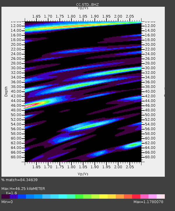
| Estimated Moho Depth: |
46.25 km |
| Estimated Crust Vp/Vs: |
1.60 |
| Assumed Crust Vp: |
6.566 km/s |
| Estimated Crust Vs: |
4.104 km/s |
| Estimated Crust Poisson's Ratio: |
0.18 |
|
| Radial Match: |
84.34639 % |
| Radial Bump: |
400 |
| Transverse Match: |
77.87301 % |
| Transverse Bump: |
400 |
| SOD ConfigId: |
21709731 |
| Insert Time: |
2020-06-27 16:00:30.542 +0000 |
| GWidth: |
2.5 |
| Max Bumps: |
400 |
| Tol: |
0.001 |
|

Signal To Noise
| Channel | StoN | STA | LTA |
| CC:STD: :BHZ:20200613T16:02:53.144978Z | 6.0822964 | 7.571251E-7 | 1.2448014E-7 |
| CC:STD: :BHN:20200613T16:02:53.144978Z | 2.8158152 | 2.2390341E-7 | 7.9516376E-8 |
| CC:STD: :BHE:20200613T16:02:53.144978Z | 1.1396658 | 1.7750247E-7 | 1.5574958E-7 |
| Arrivals |
| Ps | 4.4 SECOND |
| PpPs | 18 SECOND |
| PsPs/PpSs | 22 SECOND |


