You are here: Home > Network List > CN - Canadian National Seismograph Network Stations List
> Station DI2B Dawson Inlet, BC, CA > Earthquake Result Viewer
DI2B Dawson Inlet, BC, CA - Earthquake Result Viewer
| Earthquake location: |
Ryukyu Islands, Japan |
| Earthquake latitude/longitude: |
28.9/128.3 |
| Earthquake time(UTC): |
2020/06/13 (165) 15:51:23 GMT |
| Earthquake Depth: |
160 km |
| Earthquake Magnitude: |
6.6 Mww |
| Earthquake Catalog/Contributor: |
NEIC PDE/us |
|
| Network: |
CN Canadian National Seismograph Network |
| Station: |
DI2B Dawson Inlet, BC, CA |
| Lat/Lon: |
53.20 N/132.48 W |
| Elevation: |
82 m |
|
| Distance: |
72.6 deg |
| Az: |
38.487 deg |
| Baz: |
294.939 deg |
| Ray Param: |
0.053170145 |
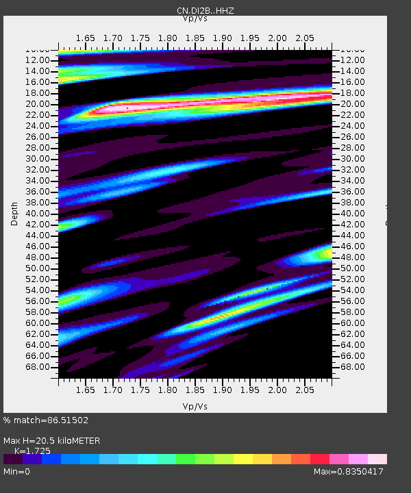
| Estimated Moho Depth: |
20.5 km |
| Estimated Crust Vp/Vs: |
1.73 |
| Assumed Crust Vp: |
6.183 km/s |
| Estimated Crust Vs: |
3.584 km/s |
| Estimated Crust Poisson's Ratio: |
0.25 |
|
| Radial Match: |
86.51502 % |
| Radial Bump: |
400 |
| Transverse Match: |
74.57934 % |
| Transverse Bump: |
400 |
| SOD ConfigId: |
21709731 |
| Insert Time: |
2020-06-27 16:02:39.812 +0000 |
| GWidth: |
2.5 |
| Max Bumps: |
400 |
| Tol: |
0.001 |
|

Signal To Noise
| Channel | StoN | STA | LTA |
| CN:DI2B: :HHZ:20200613T16:02:02.060017Z | 8.402259 | 8.9252524E-7 | 1.0622445E-7 |
| CN:DI2B: :HHN:20200613T16:02:02.060017Z | 3.031774 | 3.7155598E-7 | 1.2255398E-7 |
| CN:DI2B: :HHE:20200613T16:02:02.060017Z | 5.6216145 | 4.5063277E-7 | 8.016074E-8 |
| Arrivals |
| Ps | 2.5 SECOND |
| PpPs | 8.7 SECOND |
| PsPs/PpSs | 11 SECOND |


