You are here: Home > Network List > KN - Kyrgyz Seismic Telemetry Network Stations List
> Station TKM2 KN.TKM2 > Earthquake Result Viewer
TKM2 KN.TKM2 - Earthquake Result Viewer
*The percent match for this event was below the threshold and hence no stack was calculated.
| Earthquake location: |
Kuril Islands |
| Earthquake latitude/longitude: |
44.6/149.4 |
| Earthquake time(UTC): |
1995/12/03 (337) 18:01:08 GMT |
| Earthquake Depth: |
33 km |
| Earthquake Magnitude: |
6.6 MB, 8.0 MS |
| Earthquake Catalog/Contributor: |
WHDF/NEIC |
|
| Network: |
KN Kyrgyz Seismic Telemetry Network |
| Station: |
TKM2 KN.TKM2 |
| Lat/Lon: |
42.92 N/75.60 E |
| Elevation: |
2020 m |
|
| Distance: |
51.6 deg |
| Az: |
295.834 deg |
| Baz: |
61.14 deg |
| Ray Param: |
$rayparam |
*The percent match for this event was below the threshold and hence was not used in the summary stack. |
|
| Radial Match: |
99.99999 % |
| Radial Bump: |
2 |
| Transverse Match: |
100.0 % |
| Transverse Bump: |
2 |
| SOD ConfigId: |
4480 |
| Insert Time: |
2010-03-08 21:16:07.861 +0000 |
| GWidth: |
2.5 |
| Max Bumps: |
400 |
| Tol: |
0.001 |
|
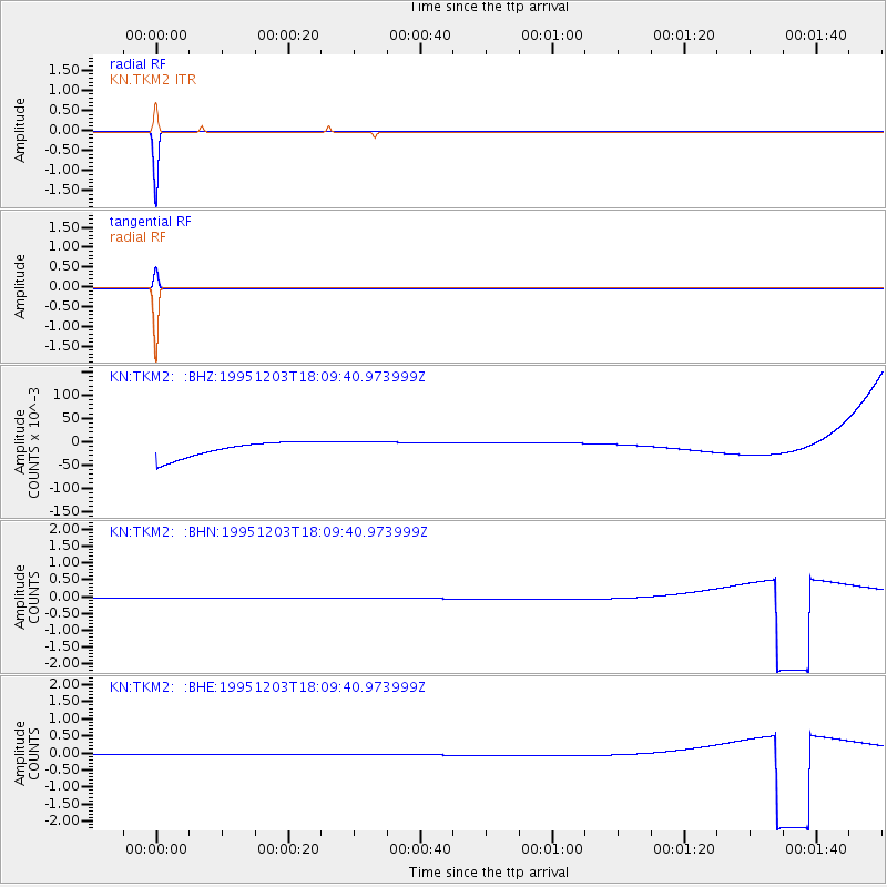
Signal To Noise
| Channel | StoN | STA | LTA |
| KN:TKM2: :BHN:19951203T18:09:40.973999Z | 0.9313456 | 0.01596811 | 0.017145205 |
| KN:TKM2: :BHE:19951203T18:09:40.973999Z | 0.9312568 | 0.015966762 | 0.017145392 |
| KN:TKM2: :BHZ:19951203T18:09:40.973999Z | 0.93124694 | 0.015966605 | 0.017145405 |
| Arrivals |
| Ps | |
| PpPs | |
| PsPs/PpSs | |


