You are here: Home > Network List > TS - TERRAscope (Southern California Seismic Network) Stations List
> Station VTV Victorville, California, USA > Earthquake Result Viewer
VTV Victorville, California, USA - Earthquake Result Viewer

| Earthquake location: |
Northern Bolivia |
| Earthquake latitude/longitude: |
-13.8/-67.6 |
| Earthquake time(UTC): |
1994/06/09 (160) 00:33:16 GMT |
| Earthquake Depth: |
637 km |
| Earthquake Magnitude: |
6.9 MB, 6.8 MS, 8.3 UNKNOWN, 8.2 MW |
| Earthquake Catalog/Contributor: |
WHDF/NEIC |
|
| Network: |
TS TERRAscope (Southern California Seismic Network) |
| Station: |
VTV Victorville, California, USA |
| Lat/Lon: |
34.57 N/117.33 W |
| Elevation: |
847 m |
|
| Distance: |
67.4 deg |
| Az: |
316.984 deg |
| Baz: |
126.582 deg |
| Ray Param: |
0.054601453 |
| Estimated Moho Depth: |
26.75 km |
| Estimated Crust Vp/Vs: |
1.82 |
| Assumed Crust Vp: |
6.276 km/s |
| Estimated Crust Vs: |
3.458 km/s |
| Estimated Crust Poisson's Ratio: |
0.28 |
|
| Radial Match: |
96.50863 % |
| Radial Bump: |
400 |
| Transverse Match: |
95.35304 % |
| Transverse Bump: |
400 |
| SOD ConfigId: |
16938 |
| Insert Time: |
2010-02-26 14:53:48.859 +0000 |
| GWidth: |
2.5 |
| Max Bumps: |
400 |
| Tol: |
0.001 |
|
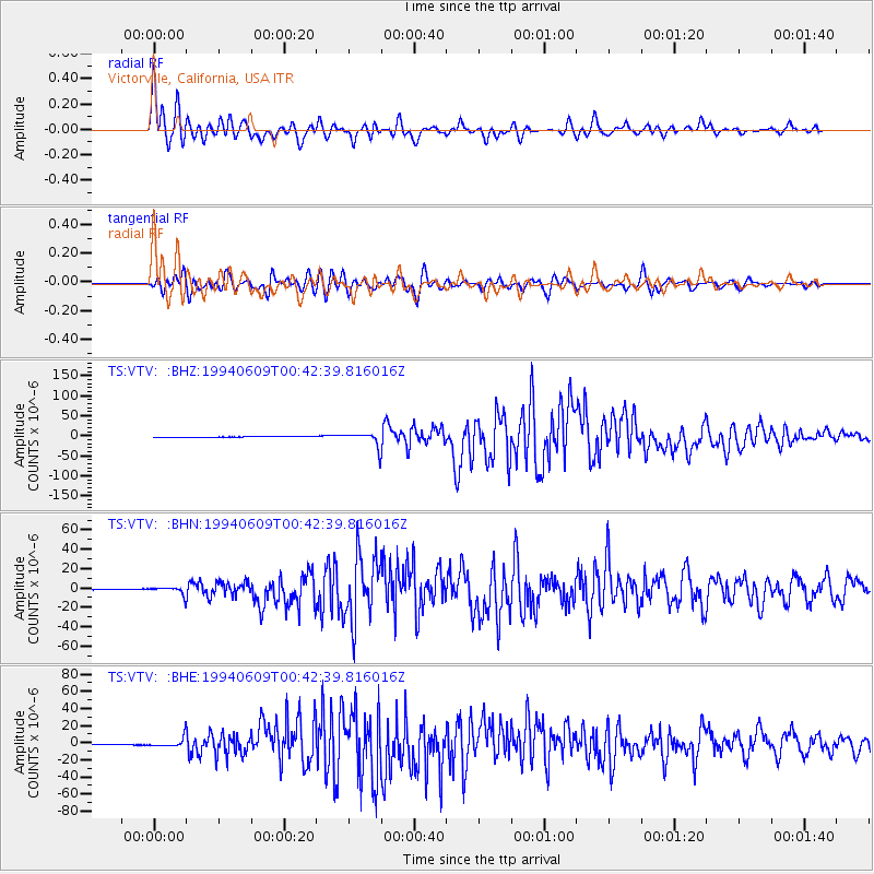
Signal To Noise
| Channel | StoN | STA | LTA |
| TS:VTV: :BHN:19940609T00:42:39.816016Z | 17.864422 | 3.863862E-6 | 2.1628809E-7 |
| TS:VTV: :BHE:19940609T00:42:39.816016Z | 14.089514 | 5.4175234E-6 | 3.8450747E-7 |
| TS:VTV: :BHZ:19940609T00:42:39.816016Z | 21.947891 | 1.8019588E-5 | 8.210168E-7 |
| Arrivals |
| Ps | 3.6 SECOND |
| PpPs | 12 SECOND |
| PsPs/PpSs | 15 SECOND |


