You are here: Home > Network List > IW - Intermountain West Stations List
> Station MOOW Moose Ponds, Wyoming, USA > Earthquake Result Viewer
MOOW Moose Ponds, Wyoming, USA - Earthquake Result Viewer
| Earthquake location: |
Aegean Sea |
| Earthquake latitude/longitude: |
38.9/26.4 |
| Earthquake time(UTC): |
2017/06/12 (163) 12:28:38 GMT |
| Earthquake Depth: |
10 km |
| Earthquake Magnitude: |
6.3 Mww |
| Earthquake Catalog/Contributor: |
NEIC PDE/us |
|
| Network: |
IW Intermountain West |
| Station: |
MOOW Moose Ponds, Wyoming, USA |
| Lat/Lon: |
43.75 N/110.74 W |
| Elevation: |
2128 m |
|
| Distance: |
89.0 deg |
| Az: |
330.442 deg |
| Baz: |
32.068 deg |
| Ray Param: |
0.042155728 |
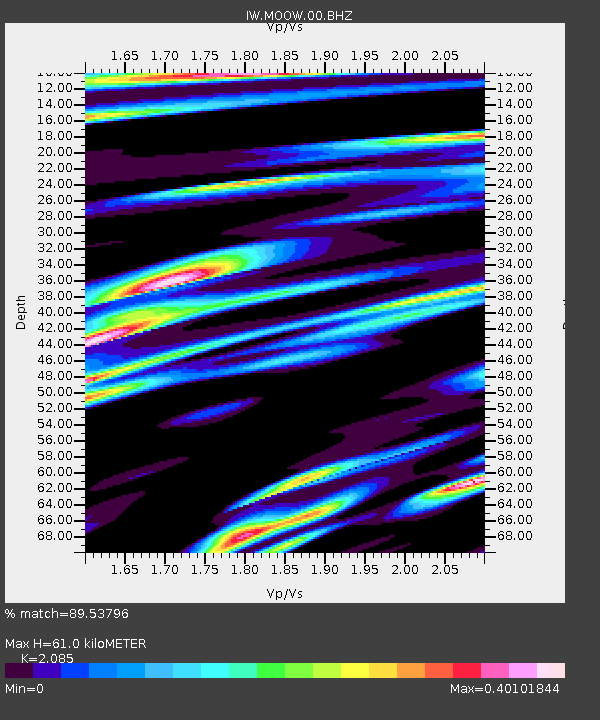
| Estimated Moho Depth: |
61.0 km |
| Estimated Crust Vp/Vs: |
2.09 |
| Assumed Crust Vp: |
6.207 km/s |
| Estimated Crust Vs: |
2.977 km/s |
| Estimated Crust Poisson's Ratio: |
0.35 |
|
| Radial Match: |
89.53796 % |
| Radial Bump: |
296 |
| Transverse Match: |
81.760506 % |
| Transverse Bump: |
400 |
| SOD ConfigId: |
2140511 |
| Insert Time: |
2017-06-26 04:24:12.416 +0000 |
| GWidth: |
2.5 |
| Max Bumps: |
400 |
| Tol: |
0.001 |
|

Signal To Noise
| Channel | StoN | STA | LTA |
| IW:MOOW:00:BHZ:20170612T12:41:02.30501Z | 11.977212 | 7.935857E-7 | 6.625796E-8 |
| IW:MOOW:00:BH1:20170612T12:41:02.30501Z | 3.5541017 | 1.922178E-7 | 5.408337E-8 |
| IW:MOOW:00:BH2:20170612T12:41:02.30501Z | 1.7563593 | 1.5362816E-7 | 8.7469665E-8 |
| Arrivals |
| Ps | 11 SECOND |
| PpPs | 30 SECOND |
| PsPs/PpSs | 41 SECOND |


