You are here: Home > Network List > KN - Kyrgyz Seismic Telemetry Network Stations List
> Station TKM2 KN.TKM2 > Earthquake Result Viewer
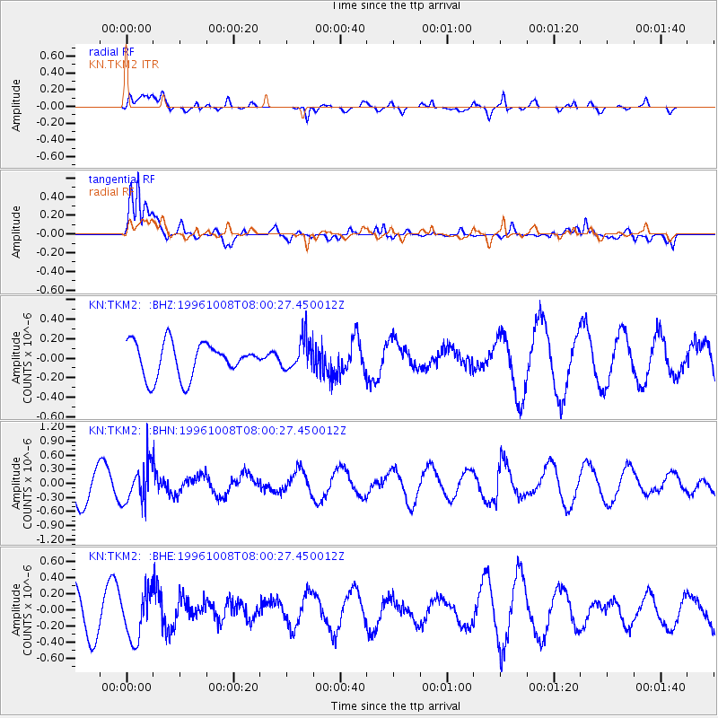
TKM2 KN.TKM2 - Earthquake Result Viewer
*The percent match for this event was below the threshold and hence no stack was calculated.
| Earthquake location: |
Northwest Of Kuril Islands |
| Earthquake latitude/longitude: |
52.9/152.5 |
| Earthquake time(UTC): |
1996/10/08 (282) 07:52:58 GMT |
| Earthquake Depth: |
627 km |
| Earthquake Magnitude: |
5.6 UNKNOWN, 5.2 MB |
| Earthquake Catalog/Contributor: |
WHDF/NEIC |
|
| Network: |
KN Kyrgyz Seismic Telemetry Network |
| Station: |
TKM2 KN.TKM2 |
| Lat/Lon: |
42.92 N/75.60 E |
| Elevation: |
2020 m |
|
| Distance: |
50.2 deg |
| Az: |
291.318 deg |
| Baz: |
50.239 deg |
| Ray Param: |
$rayparam |
*The percent match for this event was below the threshold and hence was not used in the summary stack. |
|
| Radial Match: |
48.75127 % |
| Radial Bump: |
400 |
| Transverse Match: |
77.381485 % |
| Transverse Bump: |
400 |
| SOD ConfigId: |
4480 |
| Insert Time: |
2010-03-08 21:16:19.155 +0000 |
| GWidth: |
2.5 |
| Max Bumps: |
400 |
| Tol: |
0.001 |
|
Signal To Noise
| Channel | StoN | STA | LTA |
| KN:TKM2: :BHN:19961008T08:00:27.450012Z | 1.3548069 | 4.14724E-7 | 3.0611304E-7 |
| KN:TKM2: :BHE:19961008T08:00:27.450012Z | 1.234879 | 2.8756955E-7 | 2.3287265E-7 |
| KN:TKM2: :BHZ:19961008T08:00:27.450012Z | 0.97979146 | 1.7055798E-7 | 1.740758E-7 |
| Arrivals |
| Ps | |
| PpPs | |
| PsPs/PpSs | |


