You are here: Home > Network List > KN - Kyrgyz Seismic Telemetry Network Stations List
> Station TKM2 KN.TKM2 > Earthquake Result Viewer
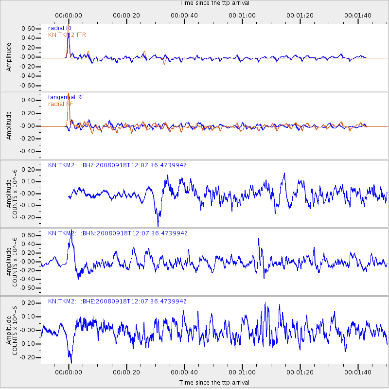
TKM2 KN.TKM2 - Earthquake Result Viewer
*The percent match for this event was below the threshold and hence no stack was calculated.
| Earthquake location: |
Near East Coast Of Kamchatka |
| Earthquake latitude/longitude: |
51.9/158.4 |
| Earthquake time(UTC): |
2008/09/18 (262) 11:58:50 GMT |
| Earthquake Depth: |
67 km |
| Earthquake Magnitude: |
5.7 MB, 5.9 MW, 5.8 MW |
| Earthquake Catalog/Contributor: |
WHDF/NEIC |
|
| Network: |
KN Kyrgyz Seismic Telemetry Network |
| Station: |
TKM2 KN.TKM2 |
| Lat/Lon: |
42.92 N/75.60 E |
| Elevation: |
2020 m |
|
| Distance: |
53.9 deg |
| Az: |
295.515 deg |
| Baz: |
49.542 deg |
| Ray Param: |
$rayparam |
*The percent match for this event was below the threshold and hence was not used in the summary stack. |
|
| Radial Match: |
78.45055 % |
| Radial Bump: |
400 |
| Transverse Match: |
58.23489 % |
| Transverse Bump: |
400 |
| SOD ConfigId: |
2560 |
| Insert Time: |
2010-03-08 21:16:22.273 +0000 |
| GWidth: |
2.5 |
| Max Bumps: |
400 |
| Tol: |
0.001 |
|
Signal To Noise
| Channel | StoN | STA | LTA |
| KN:TKM2: :BHN:20080918T12:07:36.473994Z | 6.734825 | 3.357854E-7 | 4.985807E-8 |
| KN:TKM2: :BHE:20080918T12:07:36.473994Z | 3.6027617 | 1.0762879E-7 | 2.987397E-8 |
| KN:TKM2: :BHZ:20080918T12:07:36.473994Z | 5.6285095 | 1.2140947E-7 | 2.1570449E-8 |
| Arrivals |
| Ps | |
| PpPs | |
| PsPs/PpSs | |


