You are here: Home > Network List > EI - Irish National Seismic Network (INSN) Stations List
> Station ILTH Corrakit Louth > Earthquake Result Viewer
ILTH Corrakit Louth - Earthquake Result Viewer
| Earthquake location: |
Ryukyu Islands, Japan |
| Earthquake latitude/longitude: |
28.9/128.3 |
| Earthquake time(UTC): |
2020/06/13 (165) 15:51:23 GMT |
| Earthquake Depth: |
160 km |
| Earthquake Magnitude: |
6.6 Mww |
| Earthquake Catalog/Contributor: |
NEIC PDE/us |
|
| Network: |
EI Irish National Seismic Network (INSN) |
| Station: |
ILTH Corrakit Louth |
| Lat/Lon: |
54.06 N/6.27 W |
| Elevation: |
227 m |
|
| Distance: |
88.5 deg |
| Az: |
335.136 deg |
| Baz: |
38.689 deg |
| Ray Param: |
0.042199153 |
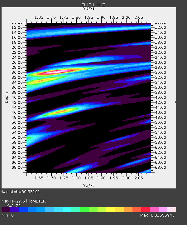
| Estimated Moho Depth: |
29.5 km |
| Estimated Crust Vp/Vs: |
1.72 |
| Assumed Crust Vp: |
6.276 km/s |
| Estimated Crust Vs: |
3.649 km/s |
| Estimated Crust Poisson's Ratio: |
0.24 |
|
| Radial Match: |
80.95191 % |
| Radial Bump: |
400 |
| Transverse Match: |
44.8561 % |
| Transverse Bump: |
400 |
| SOD ConfigId: |
21709731 |
| Insert Time: |
2020-06-27 16:04:53.176 +0000 |
| GWidth: |
2.5 |
| Max Bumps: |
400 |
| Tol: |
0.001 |
|

Signal To Noise
| Channel | StoN | STA | LTA |
| EI:ILTH: :HHZ:20200613T16:03:26.440021Z | 10.964605 | 1.823304E-6 | 1.6628998E-7 |
| EI:ILTH: :HHN:20200613T16:03:26.440021Z | 2.8880584 | 4.9859085E-7 | 1.7263878E-7 |
| EI:ILTH: :HHE:20200613T16:03:26.440021Z | 1.1466283 | 2.5286553E-7 | 2.2052966E-7 |
| Arrivals |
| Ps | 3.5 SECOND |
| PpPs | 13 SECOND |
| PsPs/PpSs | 16 SECOND |


