You are here: Home > Network List > GB - Great Britain Seismograph Network Stations List
> Station JSA ST AUBINS, JERSEY > Earthquake Result Viewer
JSA ST AUBINS, JERSEY - Earthquake Result Viewer
| Earthquake location: |
Ryukyu Islands, Japan |
| Earthquake latitude/longitude: |
28.9/128.3 |
| Earthquake time(UTC): |
2020/06/13 (165) 15:51:23 GMT |
| Earthquake Depth: |
160 km |
| Earthquake Magnitude: |
6.6 Mww |
| Earthquake Catalog/Contributor: |
NEIC PDE/us |
|
| Network: |
GB Great Britain Seismograph Network |
| Station: |
JSA ST AUBINS, JERSEY |
| Lat/Lon: |
49.19 N/2.17 W |
| Elevation: |
39 m |
|
| Distance: |
90.6 deg |
| Az: |
330.039 deg |
| Baz: |
41.851 deg |
| Ray Param: |
0.041653845 |
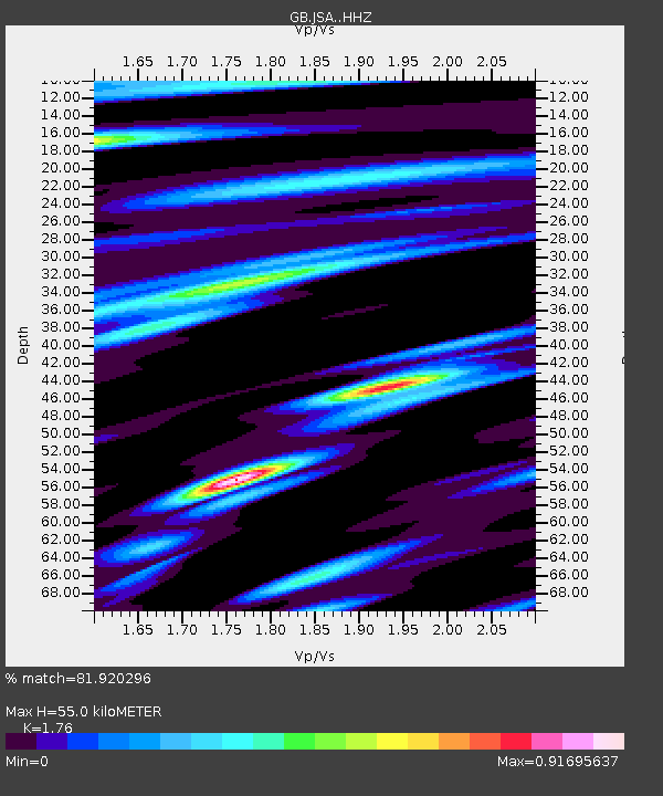
| Estimated Moho Depth: |
55.0 km |
| Estimated Crust Vp/Vs: |
1.76 |
| Assumed Crust Vp: |
6.24 km/s |
| Estimated Crust Vs: |
3.545 km/s |
| Estimated Crust Poisson's Ratio: |
0.26 |
|
| Radial Match: |
81.920296 % |
| Radial Bump: |
400 |
| Transverse Match: |
65.35601 % |
| Transverse Bump: |
400 |
| SOD ConfigId: |
21709731 |
| Insert Time: |
2020-06-27 16:05:35.958 +0000 |
| GWidth: |
2.5 |
| Max Bumps: |
400 |
| Tol: |
0.001 |
|

Signal To Noise
| Channel | StoN | STA | LTA |
| GB:JSA: :HHZ:20200613T16:03:36.039997Z | 8.934008 | 1.7576905E-6 | 1.9674155E-7 |
| GB:JSA: :HHN:20200613T16:03:36.039997Z | 2.9490519 | 5.5731897E-7 | 1.8898243E-7 |
| GB:JSA: :HHE:20200613T16:03:36.039997Z | 3.2385085 | 4.79718E-7 | 1.481293E-7 |
| Arrivals |
| Ps | 6.8 SECOND |
| PpPs | 24 SECOND |
| PsPs/PpSs | 31 SECOND |


